Monday, 30 June 2014

Richard Grice 1858-1911

On page 31 of the third edition of the book Early days of Berwick and it's surrounding districts is this short reference to Richard Grice and a tablet which was erected in his honour in Berwick Boulevard (or High Street Berwick as we know it today.)


The plaque is no longer there, it was removed when the public toilet was built in High Street. One of the long term City of Casey officers made  a few enquires for me and found that the plaque was stored safely at a Council depot. They sent me a photograph of it, see below.


Who was Richard Grice? Here's what I have found out about him. Richard Grice was born in 1858 in Collingwood. His parents were Richard Grice (1813-1882) and Ann Lavinia Hibberson (1822-1905).  Richard Grice senior, had arrived in Victoria in 1839, being ‘amply supplied with funds by his family’. He and his business partner, Benjamin Heape, set up in business together. Grice was soon a leading pastoralist and his land holdings included the Mount Alexander run near Castlemaine. In August 1844 he married Ann Lavinia Hibberson and they eventually settled in Melbourne. Heape returned to England and Grice set up partnership with Theodotus Sumner.  Later, Sumner’s daughter Annie married Grice’s son James and the firm became known as Grice, Sumner and Co. As a matter of interest, Alice Sumner, another daughter of Theodotus, married Charles Snodgrass Ryan and they became the parents of Maie Casey (Lady Casey). The firm Grice, Sumner and Co was one of the oldest mercantile houses in Australia and held large tracts of land in Victoria, New South Wales, South Australia and Queensland. Grice senior, died in Fitzroy in 1882 and left an estate valued at £320, 000 - a substantial amount of money.

Richard senior and Ann had twelve children, but there were only seven living when he passed away in 1882. One son, John, was given a Knighthood and was Vice Chancellor of Melbourne University and had substantial business interests. Another brother, James, was a foundation member of the Victorian Amateur Turf Club and Chairman on a number of occasions. As you can see, the Grice family was well connected and part of the Establishment.

This brings us to Richard Junior, the man whose name is on the plaque that was previously located in High Street, Berwick.  Richard married Louisa Jane Currie (1858-1908) in 1884. Louisa was the daughter of John Lang Currie. Currie, described as a ‘pioneer squatter’, had arrived in Victoria in 1841 and when he died in 1898 he left an Estate valued at over £517,000. He left his daughter, Louisa Grice, £30,000 of which she had already received £7,000. Given that the average wage in the manufacturing industry at the time was around £130.00 per annum, that’s serious money.

Richard purchased 710 acres in the Shire of Cranbourne in 1884 and in 1887 he purchased 234 acres in the Shire of Berwick. It was on the Cranbourne property that they built the wonderful house, Eyrecourt most likely in 1887 or 1888.   When the house was built the property was known as Eirruc (Currie spelt backwards, perhaps indicating that some of Louisa’s family money paid for the Estate).

Eirruc or Eyrecourt by Charlie Hammond
State Library of Victoria   http://handle.slv.vic.gov.au/10381/149421

This is Eirruc, later known as Eyrecourt, built by Richard and Louisa Grice. This illustration is from the Sketchbook of Charlie Hammond, held at the State Library of Victoria. The sketchbook contains both photographs and illustrations of various houses in Victoria. The book has been digitised by the State Library of Victoria and can be seen here. This house is on the City of Casey Heritage Study - to see the full citation click here. They have it listed as Eyre Court, so you will need to type this into the search box.

The Grices sold off parcels of land  from around 1906 and the Eyrecourt homestead (at 211 Grices Road, Clyde North)  in 1908. Grice did retain some Berwick property as he was living there when he died on September 6, 1911. His Probate Record lists all his assets and, amongst other property, Grice had 66 acres in the Shire of Cranbourne; a weatherboard house, Wonalta,  described as  seven rooms, plus kitchen, bathroom, scullery and outbuildings on three acres in Berwick; a block of land on Station Street (Gloucester Avenue) and another block on Elgin Street in Berwick.

Richard was described as a pastoralist or grazier and, like his brother James, had an interest in horse racing. They owned Hova who won the Newmarket Handicap in 1894 and was ‘beaten by a neck’ in the 1895 Melbourne Cup by Acracia. They also owned Crysalite who won the Australian Hurdle Race in 1899. Grice was also a member of the Victorian Racing Club, the Melbourne Hounds and the Mornington Farmers Society. He was a Shire of Cranbourne Councillor from 1894 until 1903 and Shire President 1898-99.

Richard and Jane had three children - John Alan born 1885; Henrietta May born 1889 and Annie Elinor Julia born 1894. This is what I could find out about Richard’s children.
John - The Ancestry database has the New South Wales Electoral Rolls from 1930 and John is listed in 1930 at Corowa, but he is not listed in the Victorian Rolls before 1930, so I assume that he was in New South Wales for most of his life.  I haven’t been able to find out if he was married or had children and there is no wife listed with him in the Electoral Rolls. John died in 1932 in Corowa.

Henrietta May - I found her in the Victorian Electoral Rolls in 1914 at Mount Elephant at Derinallum. Her grandfather, John Lang Currie, owned Larra at the foot of Mount Elephant and when he died in 1898 it was taken over by his son, John Lang Currie junior, so I assume she was living with her Uncle and cousins. According to the social columns of many Australian newspapers, May (as she seemed to be called) married Auburn (sometimes written as Aubyn) Wilson in London in May 1915. There are a few other reports about her staying with her sister in London at this time. She died on February 28, 1922 in England.

Annie Elinor Julia married Lieutenant Percy Robert Murdoch Collins in London in May 1915. Sadly, he was killed in action near Ypres in France on June 25, 1917 and Annie died on December 8, 1918 in London. Percy was the son of Henry and Isabella Collins of Frankston and in October 1925 a stained glass window in St Paul’s Anglican Church in Frankston was dedicated to the memory of Percy and Annie.

Richard and Jane are buried at the Berwick Cemetery. In 1912 the plaque was erected to the memory of Richard Grice in High Street in Berwick. It was erected by the Berwick Town Improvement Association. It was decided at a meeting in June 1912 to erect the plaque (see article from Berwick Shire News dated June 19, 1912 next page)  but I haven’t been able to find the exact date the plaque was placed in High Street.


Berwick Shire News June 19, 1912

Sources:
Ancestry Family History database. Available at Casey Cardinia Library Corporation.
Australian Dictionary of Biography - on-line at http://adb.anu.edu.au. This provided information about Richard Grice senior and John Lang Currie.
Berwick Shire News and Pakenham Gazette
Berwick Shire and Cranbourne Shire Rate Books
Early days of Berwick and its surrounding districts (Berwick Pakenham Historical Society 1979)
The Good Country: Cranbourne Shire by Niel Gunson (Cranbourne Shire, 1968)
Richard Grice’s will and probate papers available on the Public Records Office of Victoria website www.prov.vic.gov.au
Trove Digitised Newspapers http://trove.nla.gov.au  Information about Richard’s brothers and Percy and Annie Collins came from various newspaper reports accessed on Trove.

Monday, 23 June 2014

Motor Garages or Service Stations

Here are a few photographs of service stations in the region. Service Stations or motor garages were established in most areas after the First World War and into the 1920s. 


This is the garage opened by Lawson Poole in December  1919 on the corner of High Street and Sladen Streets in Cranboure - right opposite the Shire Offices. I believe that the garage was built by Lawson's father, William Burdett Poole for his only son. You can read more about Lawson Poole and his wife Laura, and their contribution to the Cranbourne community here.


South Bourke and Mornington Journal 18 December 18,  1919

 Lawson's 21st birthday party was also held in the newly opened garage as this report on the South Bourke and Mornington Journal of December 19, 1919 attests.

Lawson Poole's garage 
Cranbourne Shire Historical Society photograph

Another view of Poole's garage, above, looking west down Sladen Street - the house next to the garage belonged to the Pooles.


Dusting's garage, Koo-Wee-Rup circa 1926
 Koo-Wee-Rup Swamp Historical Society photograph

The building on the right, above, is Dusting's garage in Koo-Wee-Rup It was built around 1926 by Ernie Mills and taken over by Robert Dusting around 1930. As you can see by the picture below at sometime fashionable Spanish Mission style architectural details were added to the building - the bricks were rendered and the terracotta tiles were added to the parapet. The building is still standing in Rossiter Road and is now a vet's surgery.

  Koo-Wee-Rup Swamp Historical Society photograph


The upgrading of Dusting's Garage may have coincided with Mr Dusting securing a Ford dealership - this advertisement was in the Koo-Wee-Rup Sun of September 8, 1932.

 Mills and Davey garage, Koo-Wee-Rup
Koo-Wee-Rup Swamp Historical Society photograph.

The photograph, above, shows Mills and Davey's garage in Station Street in Koo-Wee-Rup It was built about 1923. They were agents for Dodge motor cars. The building is still standing in Station Street in Koo-Wee-Rup.


This is an advertisement from the Koo-Wee-Rup Sun of January 1924 - for Mills and Davey's 'up to date motor garage' with a 'first-class mechanic, late of Dodge Bros, America'

Friday, 30 May 2014

Emerald Country Club

The Emerald Country Club was established in the 1920s on part of the land originally owned by Carl Axel Nobelius who operated the Gembrook Nurseries from 1886. After Carl died on December 31, 1921 the nursery was sold to a syndicate who developed part of the property as the Emerald Country Club. Two of Carl's sons, Cliff and Arch, operated the nursery business until 1955.

The land was developed into a Country Club with a golf course, tennis courts and swimming pool and  a housing estate (more on that later). Before the Country Club house was built in 1929, Nobelius' house, Carramar, was used for this purpose. Carramar still exists and is now a private home.

The Argus February 22, 1941 http://nla.gov.au/nla.news-article8175507

Carramar was sold by the Country Club, perhaps in the 1930s when they were alleged to have gone into liquidation. I don't  have  a photograph of Carramar but I have found this advertisement for the sale of the house in The Argus from February 22, 1941. The house is described as containing three reception rooms, a full sized billiard room, five bedrooms, two bathrooms, excellent domestic and staff accommodation as well as a detached gardener's cottage of six rooms. As the land had the finest collection of trees in the State and was just under five hectares, a gardener was no doubt essential.


Emerald Country Club
State Library of Victoria Image Image H32492/3631

The Emerald Country Club house was completed in 1929 and was designed by Architects Cowper, Murphy and Appleford. Amongst other works they designed the interior of the Sun Theatre in Yarraville (opened 1938); St Moritz ice skating rink (1939); the Dendy Theatre in Brighton (1940); they rebuilt the Regent Theatre in Collins Street to the original design after a fire in 1947 and had  also undertaken interior work on the Palace Theatre in Bourke Street in the mid 1950s.

The citation on the National Trust Heritage Register describes the building as  The clubhouse design follows the American Craftsman and English Arts & Crafts Bungalow precedents in its use of the low gabled form, local rubble freestone (inside and out), and other natural finishes such as the Marseilles pattern terracotta roof tiles, stained and lacquered timber linings and joinery (interior).... This conscious use of natural material is also reflected in the construction of the log lake-side pavillion (presumed originally roofed with paling/shingle). 

When the Club first started the membership was limited to those who purchased land in the surrounding estate which was created by the establishment of Elm Crescent, Poplar Crescent, Sycamore Avenue, Oak Avenue, Nobelius Street and Lakeside Drive, which lead into the Club. A number of houses built from the 1920s on this estate still remain. You can find out more information about these houses and some of the significant trees  here on the Australian Heritage Database.

The Country Club, Emerald
State Library of Victoria Image H32492/1154

The Country Club went through various owners - in 1932 club members formed a new Company to purchase the golf course and Club house - the asking price was 14,850 pounds. Five years later another Company was formed and the asking price had halved to 7,000 pounds. In the 1970s the golf course was enlarged to 18 holes and it still in existence today. More of the history of the Club can be found on the Australian Heritage Datebase entry referred to above.

Ist fairway Country Club, Emerald
State Library of Victoria Image H32492/3532


Women's Weekly May 9, 1956  Trove http://trove.nla.gov.au/newspaper Photographer: John Askew.

This picture is from the Women's Weekly of May 9 1956 and shows Mr Clifford Wright watching an iron shot by Mr Ray Hawkins at the Emerald Country Club. The caption also mentions some of the features of the Club including tennis courts, a natural lake (ideal for swimming and fishing), bowling and putting greens, a scenic golf course with some of its fairways carved out of dense forest.


I have created a list of newspaper articles about the Emerald Country Club on Trove, click here to access the list.


Friday, 16 May 2014

Narre Warren Railway Station - the early years

The Narre Warren Railway station was opened on March 10 1882. When the Gippsland line was established in stages from 1877 to 1879 the only stations between Dandenong and Bunyip were Berwick and Pakenham.

Narre Warren Railway Station, circa 1900 to 1910.
State Library of Victoria Image H2012.171/340. Max Thomson collection.
Photographer Michael J. Drew

Sidney Webb, of Holly Green, Narre Warren agitated for the establishment of  a railway station near his property and his shops - Holly Green is located  where the Fountain Gate Shopping Centre is now and Webb's shops were on the corner of the Princes Highway and what is now Webb street.


Once the Station was opened Sidney Webb agitated again, this time for a a road to be put through to connect 'the township' with the Station (see excerpt, above, from Early days of Berwick)   In reality the 'township' did, I believe, pretty much consist of shops that Webb had an interest in. According to the Shire of Berwick Rate Books, in 1888 and 1889 a number of businesses were established in Narre Warren -  Albert Raduchel, a blacksmith; Thomas Woodley, a baker; Thomas Stones, a butcher and James Middleton, a storekeeper. They all leased their premises from Sidney Webb. 


Shire of Berwick Minutes from the meeting held April 1, 1882.

As we can see from the Shire of Berwick Minutes, Captain Wauchope, requested that the new road to the station be called Roseneath Road.  The Council did agree at the time. I don't know what happened to Roseneath Road, is it now Webb Street?.


Shire of Berwick Minutes from the meeting held April 29, 1882.

The name Narre Warren originally referred to the township of Narre Warren North. George Rae established a store at Narre Warren North, in the corner of John Troup’s paddock in 1857 and the town was surveyed around  1860. I don't know the exact date when the decision was made to call this new station Narre Warren but it appears that the Shire of Berwick had  role in the naming of the station, as it was mentioned  in the minutes of the April 29, 1882 meeting that the name for the new station had been 'noted'. (see above) Sadly, that's all I can find of this issue, it would be interesting to know if any other names had been suggested.


Shire of Berwick Minutes from the meeting held May 27, 1882.

This entry from the Shire of Berwick Minutes of May 27, 1882 (reproduced above) is the first mention I can find of the Narre Warren Railway station, actually referred to by that name.  It also talks about the formation of the new road and the fact that the Council had accepted a tender of 39 pounds from Rumph Brothers (of Harkaway) for the metalling of the new Roseneath Road. 


This is from the State Government Gazette of  May 11, 1883 where there is a list of works approved by the Governor in Council that the undermentioned services be preformed without tenders being advertised. The works, costing 200 pounds, were  to construct the new road to the Narre Warren Railway Station and Walton's Road. Is this  another road to the Station and not Roseneath road,  which going by the evidence above  was finished a year earlier in 1882?. The State Government Gazette also mentions Walton's Road. I presume that this has a connection to Thomas and Eliza Walton. Thomas & Eliza arrived in Narre Warren  1852 and built Holly Green. They left in 1877 and Sidney Webb purchased Holly Green in 1880. 


The Argus  February 13, 1883, page 10 

An article in The Argus of February 13, 1883 lists a schedule of railway works which have been undertaken and completed or partially completed since July 9, 1881 when Mr Bent took office as Minister for Railways. As you can see it includes the Narre Warren siding and platform.

Wednesday, 7 May 2014

Quarries and Sand mines

This is a series of quarry photographs - taken in the 1960s and 1970s. Basalt quarries were north of the Princes Highway in Berwick and Harkaway and sand quarries were south of the Princes Highway in Lyndhurst and Cranbourne.


This is the basalt quarry where King Road becomes Robinson Road in Harkaway. It was taken December 1963.            
                                                               

These are the two basalt quarries south of A'Beckett road and west of Harkaway Road in Harkaway. The photo was taken in January 1978.


This is the basalt quarry in Noack Road in Harkaway and one of the A'Beckett Road quarries can also be seen.  Photo was taken in April 1978. I don't know when they started quarrying in Harkaway - the earliest reference I can find on Trove is from the Dandenong Advertiser of September 23, 1915. 

This is a report received at the Berwick Shire Council meeting held September 18, 1915. 
Dandenong Advertiser of September 23, 1915.    http://nla.gov.au/nla.news-article88661295


This is Wilson Quarry in Berwick - another basalt quarry. You can read all about the history of the Wilson Quarry here. The quarry opened in 1859. It is now Wilson Botanic Park.  Photograph taken December 1963.


This is a quarry in Hallam, taken in January 1970. That is General Motors Holden Factory on the left and the Freeway now passes between GMH and the Quarry. The Gippsland Railway line is south of GMH and the quarry. The section of this railway line between Oakleigh and Bunyip opened October 1877. You can read more about this line here. I have no information about this quarry, but I suspect it was a sand mine.


Taken in January 1972 this is the Lyndhurst/Hampton Park sand quarry. It is now the 'Hallam Road landfill'. The South Gippsland Highway runs along the left of the photograph. At the bottom right corner is part of the Cranbourne Golf Club.


This is the sand mine either side of Thompson's Road in Cranbourne. Photograph was taken January 1970. The road on the left of the photo is Narre Warren - Cranbourne Road. They still mine sand on the south side of Thompson Road. Apart from Cranbourne there are still sand mines in other parts of the region, especially around Lang Lang and Yannathan.


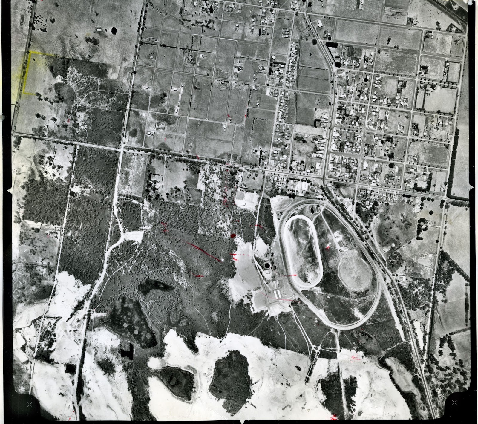
This aerial is from February 1964. These are the sand pits below the racecourse at Cranbourne, some of which now form the Botanic Gardens. Just to the south of the racecourse, where Earlston Circuit is now, was the Earlston Sand Mine, who had their own railway siding, from around the mid 1930s.  I believe there was also a line that went from the sand pits to Camms Road level crossing to service the  Cranbourne Sand Company, from the mid 1920s.


The South Bourke and Mornington Journal of September 6, 1917 had an article about 'A new Industry for Cranbourne'.  If you can;'t read the article, above, click on this link http://nla.gov.au/nla.news-article66192688 and it will take you to the article on Trove. Sand mining has thus been an industry in Cranbourne for nearly 100 years. 

Wednesday, 30 April 2014

Heritage Festival May 4 2014


The City of Casey National Trust Heritage Festival is on again - this Sunday at the Old Cheese Factory in Homestead Road in Berwick. This is a free event - here are some of the activities -  
  • Welcome to Country and smoking ceremony by Wurundjeri Elder, Bill Nicholson
  • Local Heritage Groups will have displays and can provide information
  • Heritage plays on the history of the Old Cheese Factory  by the Woodland Players
  • Free antique appraisals (no stamps, coin or jewellery)
  • Live music by the Berwick & District Folk Club
  • High Tea (please book on 8786 7900)
  • Animal farm for children  and more.
The event is from 11.00am to 4.00pm and it's free. All welcome.


Wednesday, 16 April 2014

Fountain Gate Housing Estate

The Fountain Gate housing estate, in Narre Warren, was developed by Isador Magid in the mid 1960s. He employed Robin Boyd to create the Estate on Radburn principles, which involved separating pedestrians and vehicles by providing short cul-de-sac entries and internal spines of open space. Prominent architects were also employed to design Protoype houses. The Fountain Estate is bounded by Tinks Road, Sweet Gum Avenue, Prospect Hill Road and Dawn Avenue and is listed in the City of Casey Heritage Scheme as being of local significance and possibly State significance and an innovative and imaginative housing development. Some individual houses also have Heritage listing. 


Fountain Gate Estate 1972


House and land prices at the Fountain Gate Estate from an advertisement in The Age June 17, 1976.


Fountain Gate Estate 1978. The Fountain Gate Shopping Centre wasn't opened until March 1980. The City of Berwick Civic Centre was opened in December 1978.


A copy of the original Estate plan which came with the contract of sale.


This is not very legible but it is a letter dated November 14, 1966 from Alexander Magit & Associates to the Shire of Berwick  advising us of the  approval of your Council for the erection of the motif in the form of  a fountain in accordance with the designs prepared by Mr Robin Boyd, Architect.

According to a long serving City of Casey/City of Berwick employee, this Robin Boyd fountain at the entrance to the Estate  was only turned on once when the estate was opened ( early 1970’s ) and the water went onto the highway which caused traffic problems, this may have been because the prevailing wind at the time. As you can imagine because of it’s proximity to the highway this would be a problem, which became worse when the highway was widened, it was never turned on again.


Artist's impression of the Fountain Gate Estate from 
The Age June 3, 1967.  
The fountain, which is still there, was designed by Romberg & Boyd. 


Detail of the Fountain from The Age June 3, 1967.


Photograph of the fountain from The Age June 3, 1967

There was some discussion in the early 1990s about the Fountain Gate name and whether it should become the name of  a suburb. The Fountain Gate Shopping Centre tended to dominate the area and people began to use Fountain Gate to describe the area, rather than the correct name of Narre Warren. In the end it was never adopted as a suburb name and both the Fountain Gate Housing Estate and the Shopping Centre are in Narre Warren.


This article from the Sunday Age of  February 16, 1992 mentions the controversy of the use of the name Fountain Gate as opposed to Narre Warren.  Also of interest is the price of a house $106,000. 

However, the fact that Fountain Gate was never officially adopted as a place name didn't prevent developers using the name in a proposed future housing estate, south of the Highway. This brochure isn't dated but I presume it is from the 1980s.