

This is a series of quarry photographs - taken in the 1960s and 1970s. Basalt quarries were north of the Princes Highway in Berwick and Harkaway and sand quarries were south of the Princes Highway in Lyndhurst and Cranbourne.

This is the basalt quarry where King Road becomes Robinson Road in Harkaway. It was taken December 1963.

These are the two basalt quarries south of A'Beckett road and west of Harkaway Road in Harkaway. The photo was taken in January 1978.

This is the basalt quarry in Noack Road in Harkaway and one of the A'Beckett Road quarries can also be seen. Photo was taken in April 1978. I don't know when they started quarrying in Harkaway - the earliest reference I can find on Trove is from the Dandenong Advertiser of September 23, 1915.

This is a report received at the Berwick Shire Council meeting held September 18, 1915.
Dandenong Advertiser of September 23, 1915. http://nla.gov.au/nla.news-article88661295

This is Wilson Quarry in Berwick - another basalt quarry. You can read all about the history of the Wilson Quarry here. The quarry opened in 1859. It is now Wilson Botanic Park. Photograph taken December 1963.

This is a quarry in Hallam, taken in January 1970. That is General Motors Holden Factory on the left and the Freeway now passes between GMH and the Quarry. The Gippsland Railway line is south of GMH and the quarry. The section of this railway line between Oakleigh and Bunyip opened October 1877. You can read more about this line here. I have no information about this quarry, but I suspect it was a sand mine.

Taken in January 1972 this is the Lyndhurst/Hampton Park sand quarry. It is now the 'Hallam Road landfill'. The South Gippsland Highway runs along the left of the photograph. At the bottom right corner is part of the Cranbourne Golf Club.

This is the sand mine either side of Thompson's Road in Cranbourne. Photograph was taken January 1970. The road on the left of the photo is Narre Warren - Cranbourne Road. They still mine sand on the south side of Thompson Road. Apart from Cranbourne there are still sand mines in other parts of the region, especially around Lang Lang and Yannathan.
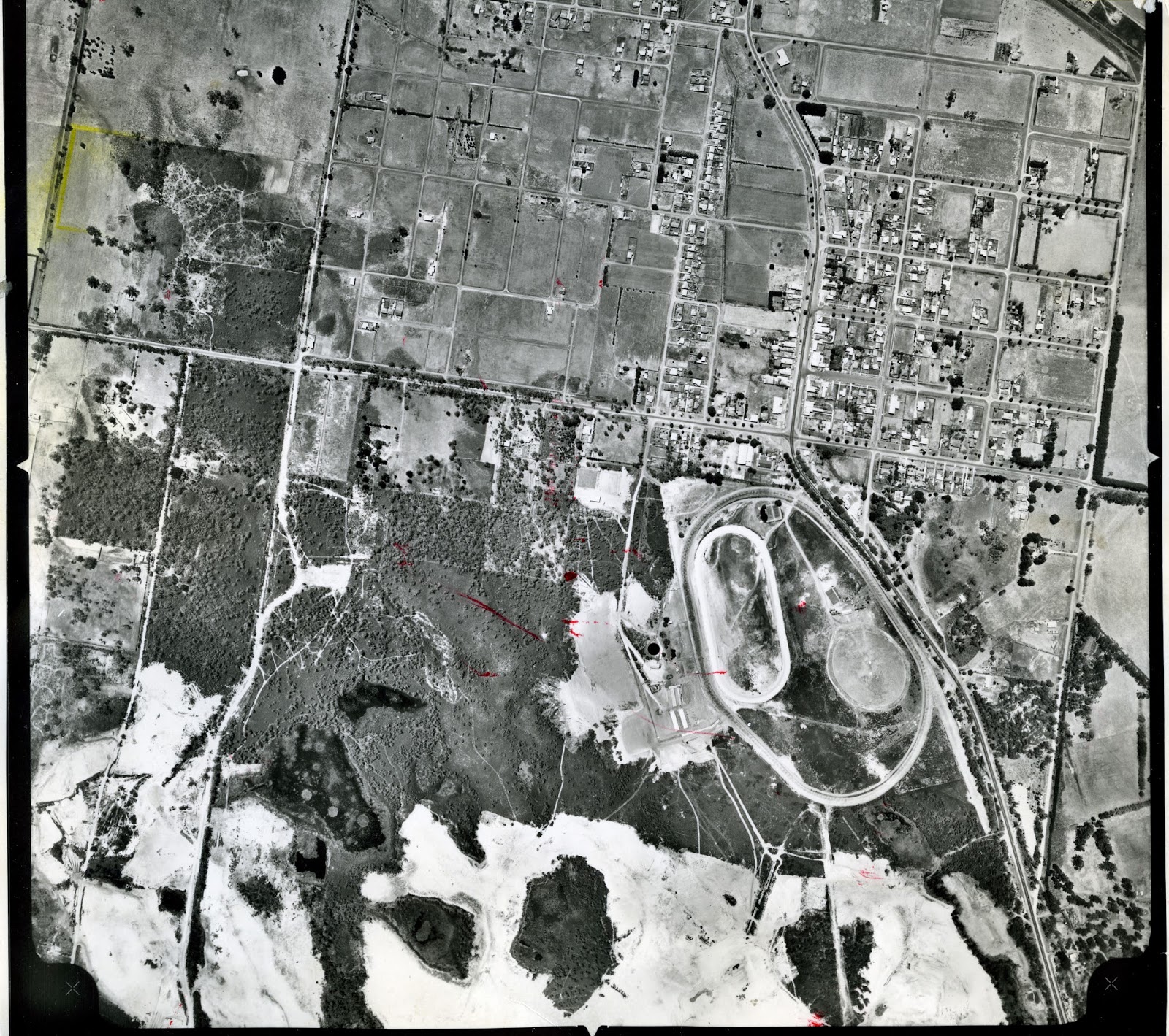
This aerial is from February 1964. These are the sand pits below the racecourse at Cranbourne, some of which now form the Botanic Gardens. Just to the south of the racecourse, where Earlston Circuit is now, was the Earlston Sand Mine, who had their own railway siding, from around the mid 1930s. I believe there was also a line that went from the sand pits to Camms Road level crossing to service the Cranbourne Sand Company, from the mid 1920s.

The South Bourke and Mornington Journal of September 6, 1917 had an article about 'A new Industry for Cranbourne'. If you can;'t read the article, above, click on this link http://nla.gov.au/nla.news-article66192688 and it will take you to the article on Trove. Sand mining has thus been an industry in Cranbourne for nearly 100 years.


2 comments:
Looking at the Hallam quarry photo, I believe you have made some errors. The freeway passes to the west of the quarry between the quarry and GMH. Also the railway line in this picture is the Pakenham line not the Cranbourne line.
Mike (long time resident of Hallam)
Thank you, Mike, for your comment. I have fixed up my errors. I don't know how I made the mistake with the Railway lines, I must not have have been thinking clearly! Thank you for reading our blog. Best wishes, Heather.
Post a Comment