Tuesday 27 December 2016

An Acrostic Seasonal history of the Casey Cardinia region - Happy New Year!

In this post we continue our eclectic look at some themes from our history and once again,  the first letter of each theme spells a seasonal greeting! In the last post we did an historic take on Merry Christmas.

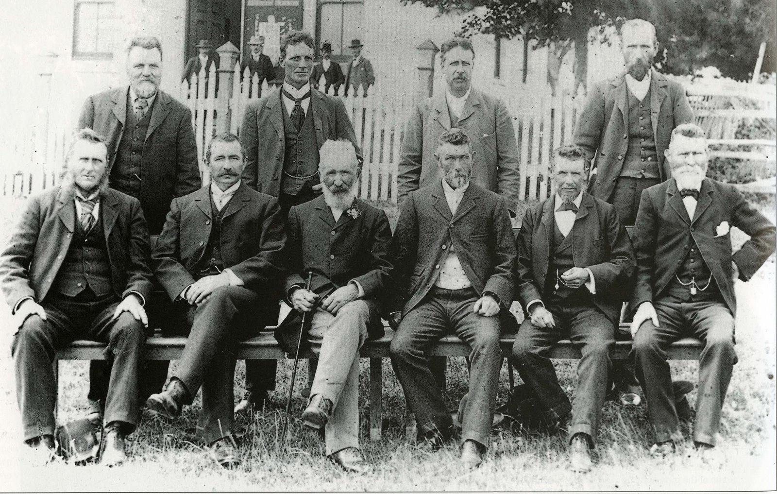
H is for Hospitals. From the 1860s, many towns local had small private hospitals run by experienced nurses and for anything more complicated (if you survived the journey)  you would have to attend one of the large public hospitals in Melbourne. Around 1909, the Bush Nursing Hospital movement developed - the local community had to raise the money to fund the cost of the nurse’s salary, board, uniform and a ‘means of locomotion’. The salary was set by the Bush Nursing Association at the rate of around £80.00 per annum, the rate of pay for a hospital nurse with five or six years experience. The first Victorian nurse was appointed to Beech Forest in March 1911 and the earliest example in this area was at  Koo-Wee-Rup when Nurse Homewood, started work in the bush nursing centre in July 1918; this hospital was later replaced by a Soldiers’ Memorial Hospital (and later still the Westernport Memorial Hospital)  The Pakenham Bush Nursing Hospital opened in February 1928 and the Berwick Bush Nursing Hospital in March 1940. The Shelley Memorial Hospital in Bunyip opened March 1966.


The official opening of the Pakenham and District Bush Nursing Hospital on Saturday, February 11, 1928. The Hospital was opened by the State Governor, Lord Somers. The local scouts formed a guard of honour. 
Photograph: North of the Line: a pictorial record compiled by the Berwick-Pakenham Historical Society.


A is for the Arts. The picturesque countryside around Emerald has attracted many writers over the years including Katharine Susannah Pritchard, Vance Palmer and Nettie Palmer. Jeannie (Mrs Aeneas) Gunn had a connection to the Hallam area and the  artist, Jessie Traill lived in Harkaway. The Boyd family, whose ranks include artists Emma Minnie (nee A'Beckett) Boyd, Arthur Merric Boyd and Arthur Boyd and the writer Martin Boyd all had  a connection to The Grange at Harkaway.


The Grange, Harkaway - rear view  by  William Gilbert a'Beckett (1864 - 1941) 
William was the sister of Emma Minnie Boyd, mentioned above.
State Library of Victoria Image H2008.111/10

P is for the Princes Highway and other roads. The Princes Highway was originally known as the Gippsland Road but its name was changed in 1920, after the visit of Edward, Prince of Wales (later Edward VIII, then the Duke of Windsor). The South Gippsland Highway was known as the Westernport Road (or sometimes the Grantville Road). The sketch map, created by William Thomas in 1840, (see below) shows how the roads developed, naturally coming from Melbourne and then on the left running down to the Mornington Peninsula and on the right through Dandenong and down to Ruffy Brothers run at Cranbourne (the start of the South Gippsland Highway). The  turnoff to the north of Ruffys that is the 'road to Mr Cloes [i.e. Clows] and onto Nerre Nerre Warren. Clow is the Reverend James Clow who took up the Tirhatuan run in 1838 - an area from Dandenong to modern day Heatherton Road which includes parts of Endeavour Hills. Nerre Nerre Warren is where the Corp of Native Police were established in 1837 (where the Police Paddocks are located)


William Thomas' sketch map form 1840
Image scanned from The Dandenong Police paddocks : early use as native police headquarters and aboriginal protectorate station, 1837-1853 by Marie Hansen Fels (Department of Conservation and Environment, 1990)


P is for Pubs. Some of the earliest establishments in all areas were Hotels - used for refreshment, accommodation and as coach stops where horses could be changed over and refreshed. One of the oldest buildings still standing in the region is the Border Hotel  also called the Berwick Inn in High Street in Berwick. The earliest part of the building was constructed in 1857 by Robert Bain. In 1850 the La Trobe Inn was established on the Toomuc Creek at Pakenham by Michael and Kitty Bourke. In 1855, David and Janet Bowman built the Gippsland Hotel on the Cardinia Creek at  Beaconsfield and in the same year  the Mornington Hotel on the corner of Narre Warren North Road and  the Gippsland Road (Princes Highway) was established by J. Gardiner and later taken over by John Payne and dismantled in the 1880s or 90s. Another Mornington Hotel was established in 1860 in Cranbourne by Thomas and Eliza Gooch and around the same time the Cranbourne Hotel was also established by Robert and Margaret Duff. The name Mornington came from the County of Mornington - for land administration purposes, the State of Victoria is divided into Counties and then Parishes, most of the Casey Cardinia region is in the County of Mornington. In the 1860s the Limerick Arms Hotel was built on the Gippsland Road at Nar Nar Goon by Daniel and Brigid O'Brien and from 1857 there were various hotels in Bunyip.

Y is for Yachts, yawls and other boats that sailed in Western Port Bay - which brings us to the Fishing Industry. Some of the earliest settlers in Tooradin were fishermen. George Casey was the first fisherman and settler, followed by Jimmy Miles and  then in 1876 Henry and Elizabeth Kernot came over from Hastings. They had eleven children including Isabella Poole. Isabella owned the Fishermans Cottage  from 1910 to 1949. It is now the home of the Cranbourne Shire Historical Society.  The Cottage is one of the few remaining examples of the fishermen’s houses that originally dotted both sides of Sawtell’s Inlet in the nineteenth century and early twentieth century. The last of the professional fishermen, Henry Kernot and Arthur Johnstone (whose mother was a Kernot), surrendered their licence in 1999.


Pomp Colvin's Patrobus, 1915 - a Tooradin Fishing boat.
Koo-Wee-Rup Swamp Historical Society photo

N is for Nature. Not only was Western Port Bay an important for fishing, both amateur and commercial, but it is also an important nature conservation area. The Department of Environment website has to say about the importance of Western Port  In 1982, a large portion of Western Port was designated as a wetland of international importance under the Convention on Wetlands of International Importance especially as Waterfowl Habitat (Ramsar Convention). The site occupies 59,297 ha and consists of large shallow intertidal areas dissected by deeper channels, and a narrow strip of adjacent coastal land in some areas. [See the full report here]  One of my favourite blog posts that I have done for this blog is one on Arcuate Ridges or curved sand ridges which are the remains of the walls of ancient lake beds. The town of Cardinia is on an arcuate ridge. Before we leave Nature we need to mention the world significant Royal Botanic Gardens at Cranbourne. There are acres of remnant bushland, plus the Australian Garden that showcases the  diversity of Australian flora from all climate environments - see more on their website www.rbg.vic.gov.au/visit-cranbourne

E is for Emergencies. Floods and bush fires have been part of the life of the community  since European settlement. The most devastating bush fire was that of Ash Wednesday fires on February 16 1983 when many lives were sadly lost and hundreds of houses and other buildings were destroyed in  Beaconsfield Upper, Cockatoo and neighbouring areas and throughout Victoria and South Australia. You can read the bald facts of this disaster here. The other emergencies we have in this region are floods, especially on the reclaimed Koo-Wee-Rup Swamp The most devasting flood took place in 1934 where up to 2 metres of water inundated the Swamp. There was also major flooding in other parts of Victoria.


Rossiter Road in Koo-Wee-Rup in the 1934 flood
Koo-Wee-Rup Swamp Historical Society photo

W is for Weekly newspapers.  This area is fortunate that it's  social life and history has been recorded in local newspapers since the 1860s. The South Bourke and Mornington Journal was published from 1865 to 1927 when it became the Dandenong Journal. We are lucky that you can access this on Trove from  1872 to 1954. This paper covered the Counties of Mornington and the southern portion of the County of Bourke (where Melbourne is located)  Other significant newspapers include the Pakenham Gazette, published by the Thomas Family since 1909. The Koo-Wee-Rup Sun and it's predecessor the Lang Lang Guardian and it's successor, The Cranbourne Sun was published from 1889 to the 1980s. Some editions of these papers are also on Trove.


The South Bourke and Mornington Journal masthead - it circulated in Dandenong, Berwick, Pakenham, Cranbourne, Brandy Creek, Grantville, Hastings, Oakleigh and Templestowe amongst other places

Y is for Yallock Creek and other waterways. The first European settlement in the area took place on creeks, for the obvious reason that water was required for 'man and beast' In 1837 Captain Robert Gardiner took up a pastoral lease at Berwick on the Cardinia Creek. In 1839  Samuel Rawson and Robert Jamieson settled on the Yallock Creek and in the same year the 14 square mile (3,600 hectares)  Eumemmerring Run, based on the Eumemmerring creek, was taken up by Dr Farquhar McCrae.


Bridge over the Cardinia Creek, 1887.
Field Naturalists' Club of Victoria photograph album, 
State Library of Victoria Image  H2012.114/1

E is for Eternal Rest or Cemeteries. We have eight cemeteries in the area - Berwick, Bunyip, Cranbourne, Gembrook, Harkaway, Lang Lang, Nangana (also called Emerald and Macclesfield) and Pakenham. You can read about them here.  Naturally in the early days people were buried quickly for health reasons and so often selected the closest burial ground and thus you can see generations of local families in the same cemetery.  With the establishment of a crematorium at the Necropolis in Springvale, this provided another option for 'eternal rest' and so if you can't find your relative in the local cemetery then they may well be at Springvale. My own grandfather, Joe Rouse from Cora Lynn, who died in 1954 was cremated at Springvale and had  a niche there, in spite of the fact that his father and daughter were at Bunyip as well as his parents-in-law - but it seemed to have been the modern way of thinking at the time.

A is for Architecture and significant buildings. Both Cardinia and Casey have undertaken Heritage Conservation Studies. The original City of Berwick Study was done in 1993 and has been updated since and the earliest Cardinia Shire one was in 1996 with updates in 1999 to cover the areas that were previously part of the Shires of Sherbrooke and Cranbourne. What would be the oldest building in Casey Cardinia? Good question - possibly the Berwick Inn (Border Hotel) - the original section was built in 1857. I'd be happy to hear of any other contenders. What is the most significant building? Possibly Edrington, the former home of Lord and Lady Casey. Lord Casey was the Governor General of Australia from September 1965 to April 1969 and apart from being a grand mansion it is this Vice Regal connection that adds to the significance. Once again, I'd be pleased to hear of any other contenders.


Edrington, Berwick, photographed in 1978.

R is for Retail or shopping. Unless you are under 35 then I don't need to tell you how shopping has changed over the years. From the mid 1850s when our towns began to develop the shops sprung up along the High Street or the Main Street - a general store, a blacksmith, a baker, a butcher  would be some of the earliest stores. Later  on there would be a boot maker, green grocer, hairdresser, perhaps a confectionary shop (I know it sounds fanciful but both Garfield and Bunyip both had one in the 1910s) maybe a tobacconist, and later on Banks, dress shops, specific grocery stores rather than a general store were established. This strip shopping was how people shopped until the development of the big shopping centres - Centro Shopping Centre in Cranbourne  and the Endeavour Hills Shopping Centre both opened in 1979 and Fountain Gate Shopping Centre in 1980 and the first major shops off Main Street in Pakenham opened with the new Safeways in 1984.


Shops in Main Street, Pakenham, c. early 1980s. 


HAPPY NEW YEAR

Monday 19 December 2016

An Acrostic Seasonal history of the Casey Cardinia region - Merry Christmas

This is an eclectic look at some themes from our history and the first letter of each theme spells a seasonal greeting! In our next post we will present an historical take on Happy New Year.

M is for Mechanics Institutes. Our earliest Library in the area is the Berwick Mechanics' Institute and Free Library which started in 1862 and is still going strong. There were once over 1,000 Mechanics' Institutes in  Victoria, many still exist as public halls, but there are now only six that still lend books, including the Berwick one. It is a remarkable achievement and there would be very  few other institutions that have played a continuous role in the history and social life our our community for over 150 years.


Berwick Mechanics' Institute 1970s

E is for Education. The earliest schools in the area opened in 1854 - there was a  school on Captain Robert Gardiner's property at Berwick - this was the fore-runner of the existing Berwick Primary School. In 1869 it was re-located to a new building on the corner of Lyall Road and Peel Street  and later moved to Lyall Road. Also in 1854 a Church of England School opened in Lyndhurst, the first teacher being Robert Davies. There were 12 boys and 10 girls at the school and they paid 2 pence per day to attend.  Free education in Victoria did not come in until 1872 when the Education Act made the Government responsible for 'free, secular and compulsory' education. Students who wished to continue their studies past Grade 8, the level at which State schools originally finished,  would have had to have gone onto a private school until State High Schools were established. Depending on where you lived in the region you could have gone to Warragul High (opened 1911) or Dandenong High (opened  1919) or Upwey High (opened 1937 as a Higher Elementary  and became a High School in 1944). Koo-Wee-Rup (opened in 1953 as a Higher Elementary and in 1957 as a High School) and the 1960s saw Doveton High open in 1960, Monbulk High  in 1963, Pakenham High in 1967 all providing local familes with closer options for continued education.

R is for Religion.  When towns were first surveyed the Government set aside sites for Churches. The earliest purpose built  Church in the area was, I believe, Scots Presbyterian Church in Cranbourne built in 1860, although before this services would have been held in private homes. This building no longer exists so the oldest church building in the area is St Johns Anglican Church in Cranbourne erected in 1865 and still in use today.   Other nineteenth century Churches in the area that are still in use for their original purpose include St Andrews Presbyterian (now Uniting) Church at Berwick built from 1879, the Avonsleigh Church of Christ built 1887 and the Koo-Wee-Rup Presbyterian Church built in 1888 as a Wesleyan Church in Cranbourne and then shifted to Koo-Wee-Rup in 1896.


Scots Presbyterian Church, Cranbourne, built in 1860 and replaced in 1953 by the existing Church.

R is for Recreation  The earliest record I can find of  any organized sport in the area is this advertisement (below) from 1860 of the Cranbourne Cricket Club's Annual dinner at the Schnapper Point Hotel. Schnapper Point is now known as Mornington. The Berwick Recreation Reserve was gazetted on July 14, 1863, five years before land was set aside in Cranbourne for 'public recreation and racecourse purposes' on August 3, 1868.


The Argus April 7, 1860 

Y is for Yuletide. 1839 is the earliest account I can find of Christmas being celebrated by European settlers with a connection to this area.  Robert Jamieson and Samuel Rawson had taken up land on the Yallock Creek and began to move cattle to the Station from November 13 1839. On their way back from Yallock they went to  Edward William Hobson’s Kangerong run at Arthurs Seat where they arrived on Christmas Eve  where  they were wassailed or toasted with a bowl of hot toddy ( a drink made from spirits, usually whiskey, hot water, sugar and lemon juice).
Christmas was celebrated in Old English style with champagne and Rawson wrote we were a merry party that evening sitting in a hut, which a beggar in England would hardly live in, the walls full of holes, the roof covered with bark through the crevices of which a person might have crept with the greatest ease, the floor the natural earth and situated in the middle of the eternal forest whence 18 months before a white man had never trod.

C is for Councils. The first form of local government in the area were the Road Boards - the Cranbourne Road Board was proclaimed June 19, 1860 and the Berwick Road Board on September 29, 1862. These Road Boards became Shire Councils in 1868 - Cranbourne on February 24 and Berwick on May 5.


Shire of Berwick Councillors, c. 1890s. 
They are photographed in front of the (now demolished)  Council Chambers, built in High Street Berwick in 1865.


H is for Holes in the ground - quarries and other extractive industries. The most  well known quarry in the area would be Wilsons Quarry at Berwick which began in 1859 and was owned by the Wilson family until 1978. It is now Wilson Botanic Park. There are other quarries in the area - the granite quarry at Tynong where the stone for the  Shrine of Remembrance was sourced is a well known example and of course there have been (and still are) sand mines at Cranbourne and Lang Lang.


 Quarry the granite for the Shrine of Remembrance at Tynong.

The caption reads (in part) Beautiful silver-grey granite of an eminently suitable kind is available at Tynong, in Gippsland, and workmen are shown in the photograph hewing the blocks of granite from the hillside. Inset:-A fine heap of granite blocks ready for dressing. They measure from six cubic foot upwards

 The Argus of November 14, 1928 http://nla.gov.au/nla.news-article3968930

R is for railways. Railways have been pivotal in the development of the Casey Cardinia Region. The Railways have always been used for personal travel - to go to work, to go into Dandenong or Melbourne for reasons such as shopping or to access medical services - but they have also influenced the location and growth of towns, transported produce to markets and tourists to holiday destinations. We have had four railway lines traversing the region and three are still operating. The earliest line is the Gippsland line to Sale which was opened from Oakleigh to Bunyip in October 1877 and fully opened in 1879. The Great Southern line commenced construction in 1887 and was fully operational from Dandenong to Korumburra by June 1891. It was later extended to Port Albert. It now only goes as far as Cranbourne. The famous Puffing Billy line, officially called the Fern Tree Gully to Gembrook line, opened in December 1900. Finally the Strzelecki line from Koo-Wee-Rup to Strzelecki opened on June 29, 1922 and closed in stages until it was completely closed in February 1959.

I is for Industry.  The 'Big Three' were established at Dandenong in the 1950s  - International Harverster in February 1952, Heinz in 1955 and General Motors Holden in 1956. Between the three of them they employed thousands of people  and they had an immediate impact on the area.  The factories required workers and even though a Railway Station was built for GMH and opened in the October or November of 1956, it was good if there was a pool of workers living close by, thus Doveton was established  as a suburb in 1954 by the Victorian Housing Commission to house these workers. The factories also accelerated the housing development in Hallam, Hampton Park and Cranbourne  from where people could drive to work and park - GMH alone  had a 1000 space car park.


International Harvester Factory, 1980s.

S is for Space. This area is notable for the Cranbourne Meteorites. So far thirteen meteorites have been discovered in the area in virtually a straight line from Officer to Clyde to Devon Meadows to Pearcedale from 1853 to 2008. You can visit the Cranbourne No. 13 meteorite at the Casey RACE Swimming pool in Cranbourne.


Cranbourne meteorite  with the chain which was employed to pull it from its position for transport to the Melbourne Museum, 21 February 1862. Photographer: Richard Daintree.

T is for Timber Industry. The Gippsland Railway line encouraged the growth of the timber industry by providing a source of transport to cart the timber to Melbourne where it was used to build houses, fences etc and as  a fuel supply. Officer and Garfield both owe their existence to the timber industry and the towns developed around the railway sidings used by the timber industry.


Carting timber at Gembrook
State Library of Victoria Image H32492/2163

M is for Market Town - that is Dandenong. The history of our area is historically linked to Dandenong as it was a service town to the surrounding area.  For instance, Dandenong had a large public hospital with specialists. It was also where the local children went to High School until local schools were built from the 1950s onwards.  Dandenong was also the major shopping area for people from the surrounding area  and a trip to the Dandenong market to buy clothes and other goods was a ritual for many. The Dandenong Market was also the major livestock market for the area. In the late 1940s and the 1950s my father used to drive his parents from Cora Lynn to the Dandenong market where they sold their eggs, chooks and calves (all carried on the back of the ute) and they were just one of the many thousands of small farmers who did the same. The Dandenong Market originally located on the corner of Lonsdale and McCrae Streets and opened in 1866, 150 years ago.  It moved to its present location on Clow Street around 1926 and in 1958 the stockyards moved to Cheltenham Road.  The Dandenong Stock Market was the last municipal owned and operated facility in Victoria, and closed on December 22, 1998. It is now a housing estate.

A is for Agriculture and farming.  Small family farms, were the main stay of the rural economy of this area from around the 1880s to the 1970s. These farms were dairy farms, poultry farms, pig farms, potato farms and market gardens.  The first settlers in the area were the squatters and large (often absentee)  landowners but from the 1850s the big squatting runs were broken up, Government land sales took place and other farmers moved in. Later on these farms were subdivided again (basically 1880s onwards)  and this gave small farmers the opportunity to purchase land - this was historically the pattern of settlement for most of our region. It was also encouraged by government schemes such as the drainage of the Koo-Wee-Rup Swamp and the Soldier Settlement Scheme after the Great War. We still have family farms in the area, but the nature of agriculture has changed and farmers need to get bigger to survive, plus there are land use competition pressures from  the ever expanding Urban Growth boundaries.


My grandma, Eva Rouse (nee Weatherhead) and my aunty, Nancy Rouse, on their small family farm at Cora Lynn, c. 1927.

S is for Swamp.  The Koo-Wee-Rup Swamp originally covered about 40,000 hectares or 96,000 acres and is part of the Western Port sunkland. The Swamp area is basically contained in  the Cardinia Shire which is about 128,000 hectares, so if you imagine that if it was left undrained, then one third of the Shire would be a Swamp.  The Chief Engineer of the Public Works Department, William Thwaites (1853 - 1907) surveyed the Swamp in 1887 and his report recommended the construction of the Bunyip Main Drain from where it entered the Swamp, in the north, to Western Port Bay and a number of smaller side drains. A tender was advertised in 1889. In spite of strikes, floods and bad weather by March 1893, the private contractors had constructed the 16 miles of the drain from the Bay to the south of Bunyip and the Public Works Department considered the Swamp was now dry enough for settlement. At one time over 500 men were employed and all the work was done by hand, using axes, shovels, mattocks and wheel barrows. By 1904, over 2,000 people including 1,400 children lived on the Swamp. Many more drains have been added over the years.


MERRY CHRISTMAS

Friday 9 December 2016

Harkaway Lutheran Chuch

I wanted to find out about Lutheran Church at Harkaway so I started with one of my key resources for the history of the area  Early Days of Berwick and its surrounding districts and this (inter alia) is what the book said about the Church -
In 1869 it was decided to erect a school building. Under the guidance of builders Weise and Mayer, the settlers built a substantial weatherboard building more generally known as the German Church. On weekdays this served as a Church and on Sundays, a Church..... Because the school was  to be also used as a church, a bell was erected bear the building in 1869.....The earliest known Lutheran Pastor was Mattias Goethe, whose signature appears on the early marriage certificates. Then came Pastor Herlitz, who was suceeded by Pastor Schramm. Rev Hermann Herlitz was Pastor of the Lutheran Church at Melbourne and head of the Lutheran General Synod of Victoria.....At Harkaway during the Pastor's  absences the service swere conducted by  Dr G. Wanke. His son, the late Immanuel, acted as organist. (Early Days of Berwick, 3rd revised edition, 1979)


This photo of the Lutheran Church and bell tower is from Early Days of Berwick, 3rd revised edition, 1979.

This didn't tell me when the Church was demolished, neither did one of my other key resources In the Wake of the Pack Tracks, so I emailed Lyn Bradley, President of the Narre Warren & District Family History Group to see if the Group had any information on the Church and she sent me back a great document from 1935,  that they have in their Research Room. We don't know who wrote the article or where it was first published but it did tell us about the closure of  the Church  -   In later years due to many changes, the church in which the early settlers took such an active interest was closed. The organ was sold in 1912 and the building disposed of for removal -  so I assume the closure date was 1912 or a bit earlier and the building removed about the same time  - however there is more about the closing date below. The following is what the document had to say about the Church -

On December 11 1869 the local members of the Lutheran Church, desirous of erecting a church building secured a site having a frontage of 100 feet to Hessell's Road. The land was purchased  from the late Dr E.Wanke for the sum of 1 pound. Five trustees were elected, namely Messrs Louis Linsing, Ernest Hillbrick, John Fritzlaff, Heinrich Edebohis and Peter Erdman. As a result of a combined effort the church members erected a building which fulfilled the dual purpose of church and State school. By voluntary subscripion a bell was obtained, its weight being 210 lbs and its pleasing tone was the pride of the pioneers.  For many years Pastor Herliz (whose son, Dr Herliz, lives at Cheltenham) made the journey from Melbourne to conduct the services. He was very popular and the services were always well attended. In those days the late Mr I.G Wanke was one of those who presided at the organ.

The late Jacob Hessell conducted school for some time until transferred to the present school building.

On July 6 1882 five new trustees were appointed, Messrs Jacob Hessell, John Fritzlaff, Rudolph Halleur, August Dubburke and Rudolph Anderson. In later years due to many changes, the church in which the early settlers took such an active interest was closed. The organ was sold in 1912 and the building disposed of for removal. Two cypress trees that were planted many years ago by the late  Gottlob Aurisich,  are still growing on the site. At the  special request of the then two remaining pioneers, the  late  I.G Wanke and R Anderson, the bell was retained, and being close to the cemetery. it is tolled on the occasion of funerals, and is always rung on New Years Eve.  Those interested having passed away the site was developed into a 'no mans land'. Consequently, on  on February 25, 1935 a public meeting was held in the local hall. Cr D Boyd presiding, and those members of the Lutheran Church who attended appointed three trustees for the site Messrs H.I Wanke, J.W Nicol and H. C Weist. Mr Wanke is chairman and Mr Weist secretary and treasurer. On Saturday last, June 8. the new trustees entered into possession to carry out out their duties

Emulating John Batman, who had 100 years ago turned the turf with  a twig on the bank of the Merri Creek, the chairman turned the turf on the site, but with a spade, and each trustee planted a tree to commemorate the occasion. The bell was removed, and the dangerous tower pulled down  after a service of more than 60 years. Thanks to the generous spirit of Mr Nicol and several other enthusiasts, material and labour is to be provided for a new tower for the bell which, it is hoped, will ring out the old and welcome in the New Year for many years to come.  

The Bell Tower was officially opened on December 28 1935.


This is a report on the election of the Church Trustees as reported in the document, above.
Dandenong Journal March 7 1935

We have found this snippet of information in the Berwick Shire Council report in the Pakenham Gazette in 1917 (see below) which refers to the 'old Lutheran Church'  so this presents two possibilities - the Church building was still there in 1917 and hadn't been removed or else the site was locally known as the 'old Lutheran Church' even though the building did not exist.  


Pakenham Gazette June 8 1917

To throw another possibility into the mix the Narre Warren & District Family History Group also have a copy of  the Harkaway Cemetery: a brief history* in which an historic overview of Harkaway was written by Val Exell on September 29, 2000.  Mrs Exell writes this about the Church - On this site the belfry and the Lutheran Church were built in 1869, the bell coming from Germany. Until destroyed by fire the building was used for school on weekdays and Church on Sundays and closed in 1912. So the 1912 closure date is confirmed but Mrs Exell says the building was burnt down and not 'disposed of for removal'  

In the end whether the Church building was burnt down or removed (or possibly both) it doesn't really matter but I was a bit surprised that the Church closed as early as 1912 given the prevalence of the German ancestry amongst the Harkaway settlers, but the building was 43 years old by then and the Harkaway Hall was only three years old (it opened on June 9, 1909) so this would have been an alternate gathering place. 


This photo of the Church is from Oak Trees and Hedges:  a pictorial history of Narre Warren, Narre Warren North and Harkaway (published by the Berwick Pakenham Historical Society in 2002)

*Harkaway Cemetery: a brief history was created through a Work for the Dole program and published in 2001 by the Peninsula Training and Employment Program Inc.

Friday 2 December 2016

Start of the Fountain Gate Shopping Centre

These fourteen photos are labelled 'the start of the Fountain Gate  Shopping Centre' They were taken by a now unknown City of Berwick staff member and show, as the name suggests, the start of the construction of the Shopping Centre.  The Fountain Gate Shopping Centre was opened on March 11, 1980 by the Governor of Victoria, Sir Henry Winneke, so these photos were most likely taken early 1979.


This is the view looking back towards the Civic Centre, which was officially opened on December 8, 1978, also by Sir Henry Winneke. Sir Henry was the Governor of Victoria from June 1974 until March 1982.


Another view looking towards the Civic Centre


Another view to the Civic Centre - there is the double storey section and what looks a bit like a colonnade on the right is section that faces the carpark on the Library side, you can see it better in the photo, below.


Similar views as above.


This is taken from the verandah on the east side of the Civic Centre, looking north.


I believe this is a view to the houses in the Fountain Gate Housing Estate on the west side of the Centre, possibly Raven Court or Fountain Drive and Summerlea Road, looking over what would be the Max Pawsey Reserve.


I believe this is looking north towards the transmission line that runs parallel to Brundrett Road in Narre Warren North


A nice row of pine (or are they cypress?)  trees - is it the same one as in the shot above? In the aerial below from January 9 1978 there are a few hedges of pines or cypress, not sure which one this is.


This is aerial of the Civic Centre (centre of photo)  and the Fountain Gate Housing Estate (top left of photo)  was taken January 9, 1978. I've included it here to see if it will help me get some orientation on the photos, hasn't really helped but it might help you. It does however show the landscape before the shopping centre was constructed. The building on the right of the Civic Centre is the Brechin Homestead, built in 1937 and demolished around 1990. You can read about it here.


I feel that this is looking north towards Narre Warren North


I think this is looking west to the Fountain Gate Housing Estate and Tinks Road


This is what became Magid Drive looking towards the Princes Highway


Looking west and the one below is looking south west. The trucks are an International Loadstar and an International Acco - both would have been made at the International Harvester Factory at Dandenong.