Showing posts with label Koo Wee Rup Swamp. Show all posts

Monday, 21 June 2021

Historic Post Office Photographs - Part 1: Koo Wee Rup Swamp and surrounding areas

As part of the 2021 Casey Cardinia Heritage Festival, Patrick Ferry gave an interesting talk about local history resources in the National Archives’ collection. A key resource Patrick highlighted was series B5919 – Master Set of Post Office Photographs (1901 - ). This series of historical photographs was originally assembled by Australia Post’s museum in Melbourne and later transferred to the National Archives. The photographs have been digitized and are available via “Record Search” on the National Archives website: www.naa.gov.au

We recorded Patrick's talk and you can see it here on our You Tube channel,   https://youtu.be/vfJjZ2iYSo0

In this post we will show you the Post Offices on the Koo Wee Rup Swamp and the towns bordering the Swamp - Lang Lang to the south; Nar Nar Goon, Tynong, Garfield and Bunyip to the north and Cardinia at the eastern end. Not every Post Office was photographed, for instance the Cora Lynn and Modella Post Office are not the collection. In the second post we look at the Post Offices in the old Shire of Cranbourne (see here). In the third post we look at the Post Offices from the old Shire of Berwick, located along the Highway or Railway line (see here).  In the fourth post we look at the Post Offices from the old Shire of Berwick, located in the Hills (see here). 

Many of these photographs were taken in the late 1960s and they are an interesting snapshot of our towns from fifty years ago as some of these buildings are no longer there, some are still in existence but are no longer Post Offices and a few are still being used as Post Offices. The photographs of the General Stores are especially interesting.


Bayles Post Office, 1969.
National Archives of Australia B5919, 149 Item ID 6528489


Bunyip Post Office.
This is an earlier photo than the two below.
National Archives of Australia B5919, 362 Item ID 6528702


Bunyip Post Office, 1968
National Archives of Australia B5919, 362 Item ID 6528702


Bunyip Post Office, 1968
National Archives of Australia B5919, 362 Item ID 6528702


Cardinia  Post Office, 1969
National Archives of Australia B5919, 421 Item ID 6528760


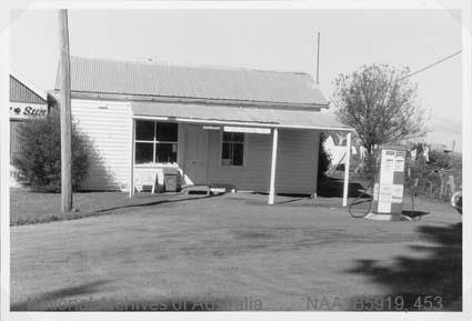
Catani Post Office, 1969
National Archives of Australia B5919, 453 Item ID 6528791


Garfield Post Office, 1969
National Archives of Australia B5919, 720 Item ID 6529062


Iona Post Office
National Archives of Australia B5919, 951 Item ID 9515098


The original Koo Wee Rup Post Office
National Archives of Australia B5919, 15/97 Item ID 5950839


Koo Wee Rup Post Office
National Archives of Australia B5919, 1066 Item ID 9515212


Koo Wee Rup Post Office, again.
Interesting view showing more of Station Street.
National Archives of Australia B5919, 1066 Item ID 9515212


Koo Wee Rup North Post Office, 1969
National Archives of Australia B5919, 1067 Item ID 9515213


Lang Lang Post Office, 1969
National Archives of Australia B5919, 1111 Item ID 9515527


Nar Nar Goon Post Office, 1968
National Archives of Australia B5919, 1531 Item ID 9515674


Pakenham South Post Office, 1968/1969. 
Incorrectly listed as Packenham South at the NAA.
National Archives of Australia B5919, 1654 Item ID 9515797


Tynong Post Office, 1968
National Archives of Australia B5919, 2165 Item ID 9699315


Vervale Post Office, c. 19671969
National Archives of Australia B5919, 2186 Item ID 9699336


Yannathan Post Office
National Archives of Australia B5919, 2378 Item ID 9699528

This post shows the Post Offices on the Koo Wee Rup Swamp and the towns bordering the Swamp - Lang Lang to the south; Nar Nar Goon, Tynong, Garfield and Bunyip to the north and Cardinia at the eastern end. In the second post we look at the Post Offices in the old Shire of Cranbourne (see here). In the third post we look at the Post Offices from the old Shire of Berwick, located along the Highway or Railway line (see here).  In the fourth post we look at the Post Offices from the old Shire of Berwick, located in the Hills (see here). 

Wednesday, 30 December 2015

A day in the Fen Country: Mr Lyall’s Breeding Stations by R. M'D.

The Leader newspaper of March 14, 1868 had a lengthy account of William Lyall's agricultural pursuits in the Fen Country. The Fens in England was a large area marshland which was reclaimed by drainage from around the 1650s to the 1800s. As Lyall's land bordered the Koo-Wee-Rup Swamp it was logical name for the area. This article is of interest for  a number of reasons - it gives  a great description of the land between Cranbourne and Tooradin and Lang Lang before the Swamp was drained - it's a landscape that is much different from today when you drive doen the South Gippsland Highway. Secondly there is the total acceptance of aims of the Acclimatisation movement - where fauna from the United Kingdom was introduced into Australia  (the rabbit being the 'best' example of this). Thirdly, I like the rivalry between Cranbourne and Berwick displayed by 'mine host' at Cranbourne.

I have edited the article , you can read the full article on Trove here http://nla.gov.au/nla.news-article197424726


It is once in seven years that I visit the fen country. That period I hold to be about the proper interval of time between one visit and another to a district that one is not intimately connected with by either birth or business. It is sufficiently long to note any progressive changes that have taken place in the scenes around one; and it is sufficiently short to enable the memory to recall the exact state of former things. My late visit has been superinduced in this way. Having occasion to penetrate into the County of Mornington the length of Cranbourne, not so much to refresh myself as the little nag that carried me thither,  I pulled up about midday at a respectable place of entertainment 'for man and beast.'
After the usual salutations, ‘and something more’ with mine host, this town, said I, inquiringly, is the capital of Mornington. 'It ought to be' said my sonsie [healthy, robust] friend but at present it is stripped of its dues.' 'How so?' said I. ' Not,' replied he ‘because it lacks any of the natural advantages that are essential to constitute a fine inland toon. We have around us the  finest agricultural land, plenty of wood, and water, honest men and bonny lasses; but that outlandish place, Berwick, has taken the agricultural show from us, for this season.' 'Is Berwick not equally suitable as a showground?' said I. 'Bless, you’ said my friend, 'will William Lyall, with his hares and pheasants and partridges; with his ponies and racers and Punches [type of draught horse] and with his enormous English sheep, and white-faced cattle, go there? Not he; it is too far away, and what can be the good of the show?'


I stood the whole of this lively recital with admirable composure, until mention was made of the ' white-faced cattle,' when former recollections of 'Old Star' and her offspring rushed in upon me, and the disposal of the morrow was very summarily' decided. A few more minutes and I was jogging on my way….. in the direction of- Tooradin, the nearest homestead or 'head station’ as we used to call such establishments, of the father of acclimatisation in Victoria - William Lyall.


This is the Acclimatisation Society's medal - which shows some of the animals introduced to Victoria - deer, ostrich, pheasant, swan, rabbit and  hare.
State Library of Victoria Image IAN20/06/68/8   


My way, for a considerable distance after leaving 'the toon o' Cranbourne,' lay through a track of country extremely dreary and suggestive of immediate action on the part of the Acclimatisation Society, in stocking its heathy hummocks with grouse and blackcock from the 'Land o' Cakes’ Then I wended on through a stunted forest of the unenviable sort of  timber commonly called ‘bastard box,' from which I at last emerged into a prairie of considerable extent, and, as far as I could judge perfectly level. This plain, through some agency that I do not here undertake to explain, is evidently year by year becoming larger.  The trees are decaying all around its margins, and stand there in thousands, branchless and bleached with the action of the weather. And here, as everywhere, else, where this decay of the forest sets in, the pasturage is very perceptibly improved. The surface soil,  in the first place, is being materially enriched with the deposit shed from dying timber; while the subsoil is not only spared the former exhaustion through the medium of the root, but is actually benefited by the presence of that root now in a state of decomposition. 

The improvement which  took place in this Plain of  Sherwood [Parish of Sherwood], since my former visit, may therefore be partly ascribed to this mysterious decay of the forest, partly to the present treatment of the pasturage (sheep grazing), and in a great measure to the free and fertilising action of the sun upon the surface. This plain, in fee simple, I am informed, is the property of an old and well known colonist, who is now for some years absent from the colon - Mr John Bakewell. It does not require the precision of prophecy to foretell that it will become, at some future day, a princely estate. It already, in natural richness and levelness, invites the presence of the steam plough; but while in a sort of reverie…. I arrived at my destination for the day, Tooradin.


This is William Lyall (1821 to 1888) on the left and John Mickle (1814 to 1885), taken in 1853. 
Photo from The Good Country: Cranbourne Shire by Niel Gunson

Mickle, Lyall and John Bakewell (1807 to 1888) were business partners who in 1851  acquired the Yallock Run (based on the Yallock Creek, south of Koo-Wee-Rup). In 1852 they acquired the Tooradin run and in 1854 they acquired the Great Swamp run and at one stage they occupied nearly all the land from Cranbourne to Lang Lang.  Lyall's sister Margaret was married to John Mickle. 


I had the good luck of finding the 'Laird' at home; but the day was too far gone to admit of seeing anything in the way of stock, beyond what some fashionable writers of  the day call 'the sires of the season'  The writer then goes on to describe the horses, including the redoubtable Dockin, famous in every show yard as the first prize Shetlander. He was supposed to be good when first purchased, in his native little island….twelve or thirteen years ago; but he is now known to be good, not wholly for winning so many fields, but for getting an innumerable race of crack animals.

The next day Lyall and the writer reviewed the sheep - These are exclusively of pure Romney Marsh blood, and spring from six or seven ewes and a ram of that breed imported  by Mr Lyall nine or ten years ago. He was induced, I believe, in a greater degree to try this breed on the Fen country from the adaptability its name indicated, than from any personal knowledge he has had of this variety of sheep; however that, maybe, the experiment has resulted to his satisfaction.  The little 'mob' now amounts to about seventy head and all of them, from the patriarch of the flock to the youngest lamb, are in fine blooming health.

They then go to view the white faced cattle and …there beamed the lovely countenances of 'Old Star' and her numerous offspring. There, the old cow stood, on the eve of bringing the thirteenth calf (her fourteenth, should she bring twins) within ten years. At the R.A.S show at Salisbury in 1857, where she stood first as the ‘best heifer in milk in calf’ she was probably as perfect a specimen of the Hereford breed as was ever seen.

The writer then has a number of paragraphs about Lyall’s cattle when they then went to see Lyall’s house, Harewood, which was under construction. Here tradesmen were busy in finishing a mansion, intended for the laird's residence. This is built of brick, on a sand hill, on the very shore of Western Port. We soon toddled up stairs to get a survey of the outlines of the district.  The dimensions of the windows were just sufficiently liberal herein to gratify my curiosity. These I found, when my surprise subsided a little to be somewhere about eighteen inches in breadth, and about four feet in height. 'What on earth' said I, 'induced you to have the windows so small?' 'This, my good fellow, in our climate, is the right sort,' replied the laird.' You never saw a more absurd or unprofitable thing' continued he ‘than first to make large windows to let in the whole blaze of day light and heat upon you, and then to send off the dray for a load of 'soft goods' to keep that light and heat out again’.


Harewood. Photographer: John T. Collins, taken April 1975. 
The photo clearly shows the windows that are about eighteen inches in breadth, and about four feet in height  that raised the curiosity of  the writer.  
State Library of Victoria  Image H97.250/1833 

My eye, by this time, was ranging to the far north, where the Dandenong mountains towered up to the clouds. Nearer to me, in that direction, not a feature was sufficiently prominent to attract my attention.  The whole expanse was one dead solitude….On turning to the south, there, away in the distance, gloomy and sombre, lay French Island and the whole bosom of the calm bay between us, thickly dotted with sea fowl and waterfowl of several varieties, whose names were as unknown to me as was their gabble, which, at moments of apparent excitement, became a perfect 'Babel.' In fact, the whole scene became too grand for a person of my temperament. I began to get a little melancholy.

Off we were again to Yallock, Mr Lyall's furthest away station. It is here the sheep are washed and shorn, for here is a running stream of fine soft water [Yallock Creek], and clean pasture to preserve the fleece, in the interval between washing and shearing, in a state of purity. The woolshed is here, too, but at the present juncture, it is converted into a stable for the colts which are undergoing a slight modicum of training, ere being brought to the hammer during the present month. ….. And, to be candid, I saw something else here that please me more than any sight of thorough-bred colts would. 'The man who makes two blades of grass grow where one grew before is a benefactor to his country.' But at Yallock, four blades are growing now to the one that grew there during my former visit. The various kinds of clovers sown around the swamp and on the sheepfolds are spreading fast and taking possession of every spot of broken surface. The close and cutting treading of the flocks too is polishing and consolidating the surface, and thus effecting a constant improvement. In fact so rapid, now-a-days, is the march of improvement in the Fen country that henceforth I see clearly, if I am , to keep myself properly posted up, I must reduce the period between my visits to one-half its former duration, that is, from seven to three and a-half years.

Monday, 1 August 2011

Wattle time

If you live on the Koo-Wee-Rup Swamp or drive through it, then you would have noticed the wattle trees are in bloom. I believe the species is the black wattle (acacia mearnsii). It grows anywhere, it is on the bank of the Main Drain from Iona to Koo-Wee-Rup and if you dig up any soil and leave it for a few weeks you will soon have black wattles growing. The trees are neat enough when they are young, but after a few years they get messy, branches break off and they begin to look a bit ugly.

Image: Heather Arnold 

The flowers are a pale yellow, not nearly as pretty as the Cootamundra wattle (acacia baileyana) or Australia's floral emblem, the Golden Wattle (Acacia pycnantha Benth.) But from late July to the first few weeks of August the Black Wattle is glorious - they line the roads and the drain banks and you can look across the paddocks and see glimpses of yellow everywhere. It really is a magnificent sight.

Main Drain Road, looking west from the Eleven Mile Bridge at Cora Lynn.
Image: Heather Arnold 

The Main Drain, looking west, from the Eleven Mile Bridge at Cora Lynn.
Image: Heather Arnold 

Image: Heather Arnold 

You can also see other remnant Swamp vegetation, including the Swamp Paperbark (melaleuca ericifolia) . The photograph, above, was taken in Dessent Road at Vervale, but you can see this everywhere, including a stand near the sandpits in Thompson Road at Cranbourne and some along the Cardinia Creek, which you can see from the Pakenham by-pass. The picture (below) was taken, I believe, around Lang Lang in 1913. The plant can grow to ten metres high.


Image: Heather Arnold 

Another common plant are the reeds (phragmites australia), they grow everywhere on the Swamp, where there is a bit of water. This was taken also taken in Dessent Road. You can also see the reeds in the photograph, below. It is part of a series of post cards produced for Koo-wee-Rup in the late 1930s or early 194os. I think that's a blackwood wattle (acacia melanoxylon) behind the bridge.

Image: Koo Wee Rup Swamp Historical Society

William Wordsworth may well have been inspired by a host of golden daffodils, but to me there is nothing better that a host of golden wattles, brief though their time of glory may be, so here's another photograph, below, taken on the corner of Main Drain Road and Eleven Mile Road, Cora Lynn.

Image: Heather Arnold 

Tuesday, 1 December 2009

The 1934 Flood

It is 75 years since the worst flood on record hit the Koo-Wee-Rup Swamp on December 1, 1934. The original Drainage works on the Swamp were completed in 1897 but later floods in 1901, 1911, 1923 and 1924 saw extra drainage work undertaken including the widening of the Main Drain and additional side drains. None of these works protected the Swamp against the big flood of 1934. 


Cora Lynn in an early flood, perhaps in the 1910s. The building on the right is the E.S.& A bank and the building in the middle is Murdoch's General Store.
Image: Rouse Family collection

There had been above average rainfall in the October and November and more heavy rain fell across the State on December 1. This rainfall caused a flood of over 100,000 megalitres or 40,000 cusecs (cubic feet per second) across the Swamp and this was only an estimate because all the gauges were washed away. The entire Swamp was inundated; water was over six feet deep (1.8metres) in parts of the Koo-Wee-Rup township. At Cora Lynn, three feet of water (about a metre) went through my grandparent’s house in Murray Road. The family, including the four children aged 11, 5, 3 and nearly 1, had to retreat to the roof. This flood also affected other parts of the State, for instance, it was reported in The Argus that there was four feet (120 cm) of water over parts of the Princes Highway between Dandenong and Berwick. Over a thousand people were left homeless as a result. The Koo-Wee-Rup locals were just recovering from this flood when another flood of about 24 000 cusecs hit in April 1935.


Rossiter Road in Koo-Wee-Rup in the 1934 flood. The photograph was taken just near the Railway line, the building on the right is St George's Anglican Church.
Image: Koo Wee Rup Swamp Historical Society

As a result of the 1934 flood, the State Rivers and Water Supply Commission (SRWSC) worked on new drainage plans for the Swamp and these plans became known as the Lupson Report after the complier, E.J Lupson, an Engineer. A Royal Commission was also established in 1936. Its role was to investigate the operation of the SRWSC. The Royal Commission report was critical of the SRWSC’s operation in the Koo-Wee-Rup Flood Protection District in a number of areas. It ordered that new plans for drainage improvements needed to be established and presented to an independent authority. Mr E. G Richie was appointed as the independent authority. The Richie Report essentially considered that the Lupson Report was “sound and well considered” and should be implemented. Work had just begun on these recommendations when the 1937 flood hit the area. The 1937 flood hit Koo-Wee-Rup on October 18th and water was 60cm (2ft) deep in Rossiter Road and Station Street. The flood peaked at 20,000 cusecs (50,000 megalitres) about half the 1934 flood volume.

Station Street, Koo-Wee-Rup, during the 1934 flood.
Image: Koo Wee Rup Swamp Historical Society

The main recommendation of the Lupson / Ritchie report was the construction of the Yallock outfall drain from Cora Lynn, cutting across to Bayles and then essentially following the line of the existing Yallock Creek to Western Port Bay. The aim was to take any flood water directly to the sea so the Main Drain could cope with the remaining water. The Yallock outfall drain was started in 1939 but the works were put on hold during the Second World War and not completed until 1956-57. The Yallock outfall drain had been originally designed using the existing farm land as a spillway i.e the Main Drain would overflow onto existing farmland and then find its own way to the Yallock outfall drain. Local farmers were unhappy at this, as the total designated spillway area was 275 acres (110 hectares). They suggested a spillway or ford be constructed at Cora Lynn so the flood water would divert to the outfall drain over the spillway. The spillway was finally constructed in 1962, though ironically its opening was delayed by yet another flood, as we can see in the photograph below.

This photograph was taken by my Uncle, Jim Rouse, in October 1962, before the official opening of the Cora Lynn spillway. The building, with the brown coloured roof, is the Cora Lynn Hall. The other buildings you can see in the background are the same as the ones on the other Cora Lynn photograph at the top of this post - the E.S.& A Bank and the general store, then Dillon's store. The road at the top left is the newly constructed spillway and you can see where flood waters have broken through the Main Drain bank and are spilling across it.

Wednesday, 6 August 2008

Carlo Catani


Drainage works on the Koo-Wee-Rup Swamp
Illustration published in the Illustrated Australian News January 1 1892
State Library of Victoria Image IAN01/01/92/20


There are a number of towns in Casey Cardinia, named after local identities. We have already looked at Pearcedale, which was named after early settlers, Nathaniel and Mary Grace Pearce. The town of Catani is named after Carlo Catani who was one of the Engineers in charge of the Koo-Wee-Rup Swamp Drainage scheme. I thought it would be interesting to find out a bit about the man behind the name.

Carlo was born on April 22 1852 in Florence in Italy. He was the son of Enrico Catani, who was a merchant, and Augusta Geri. He was educated as a Civil Engineer at the Technical Institute of Florence. Carlo and his two friends, Pietro Baracchi and Ettore Checchi, arrived in Melbourne, via New Zealand, in September 1876.

The trio were employed as draftsmen by the Department of Lands and Survey. In 1880, Catani was registered as a Surveyor and in 1882 he and Checchi joined the Public Works Department as Engineering draftsmen. By 1886, they were both assistant Engineers. Checchi (1853 - 1946) went on to become an Engineer with the State Rivers & Water Supply Commission when it was established in 1906. Baracchi (1851 - 1926)  became the Acting Government Astronomer for Victoria and later joined the Commonwealth Government as an Astrologist and Meteorologist.  Catani was promoted to the Head of his Section in 1892. In 1893, the Public Works Department resumed the control of the Swamp drainage works from private contractors and Catani was appointed as the Engineer.
Catani implemented the Village Settlement Scheme. Under this Scheme, all workers had to be married, accept a 20 acre block and spend a fortnight working on the drains for wages and a fortnight improving their block and maintaining adjoining drains. The villages were Koo-Wee-Rup, Five Mile, Cora Lynn, Vervale, Iona and Yallock.


Lubecker Steam Bucket Dredge in action. 
I suspect that this must have been taken shortly after it arrived in 1913 by the number of interested observers.
State Library of Victoria Image rwg/u866  You can see more of these photographs here

Catani was also responsible for the first mechanical equipment used on the Swamp. He had ordered the Lubecker Steam Bucket Dredge in 1912 and it arrived in 1913 at a cost of £4,700. It weighed 80 tons and had a capacity of 61 cubic metres per hour. A labourer at the time dug about 8 cubic metres per day. It was used on the Lang Lang River, then on the Main Drain, Cardinia Creek and Yallock Drain.

Catani’s other work with the Public Works Department included flood mitigation works on the Yarra River. He was responsible for planting the elms, oaks and poplars along Alexandra Avenue. He designed the Morrell bridge. The laying out and planting of the Alexandra Gardens was also carried out under Catani’s direction. His last major project was the reclamation of the St Kilda foreshore. The gardens he designed at the end of Fitzroy Street were named after him as was the Catani arch bridge on the St Kilda foreshore. There is a bronze bust of Carlo Catani on the Clock tower on the St Kilda esplanade. 
Contemporaries of Catani said that he 'saw possibilities to which others were blind' and that he had 'unfailing courtesy and a kindly nature.'

Carlo was naturalised in 1892. He married Catherine Hanley of Port Fairy on May 18 1886 at the Free Church of England in Fitzroy, by the Reverend Nathaniel Kinsman. They had six children, Edward (b.1886 and d.1887), Elvira May (1888-1947), Enrico Ferdinando (b.1891-killed in Action in France in 1916), Ettore Luigi (1893-1967), Eugenia Anastasia (1895-1915) and Enid Marguerite (1899-1950). Catani died July 20,  1918 at the age of 66 and is buried at the Brighton cemetery. Catherine died in 1925, aged 68. None of the children married.


Carlo Catani
 Koo-Wee-Rup Swamp Historical Society photo.

I looked at Enrico's Military Record and found that he was Killed in Action on July 29 1916. Enrico was a Second Lieutenant, had served at Gallipoli before serving in France. He was buried at Cemetery Post Station, near Pozieres. However in a interesting and poignant twist, in 1932 the body of an 'unknown' soldier was exhumed from another location and this was identified through the identification disc and other personal effects to be Enrico Catani. There are a series of letters in Enrico's Military file between the Australian War Graves Service and Enid Catani regarding this discovery. In the end Enrico was buried again in the Serre Road Cemetery near Beaumont Hamel, in France. The body of the Officer, who was initially thought to be Enrico, now has a headstone stating that he is an 'unknown Australian Lieutenant'. In one of the letters Enid sent to the Government regarding the discovery of her brother's body, Enid said that her surviving brother, Ettore, had never recovered from the shock of Enrico's death and is under the care of the Master-in Equity of the Supreme Court. The Master-in-Equity looked after people who did not have the legal capacity to care for themselves. It sad to think that effectively, the family lost two sons to the First World War.

You can read more about Carlo Catani, here, on a blog devoted to his life and works.

Most of this information comes from the article on Carlo Catani, written by Ronald McNicoll, in the Australian Dictionary of Biography. 

The information on his children comes from the Victorian and New South Wales, Indexes to the Births , Deaths and Marriages. 

The information on Enrico's Military Service can be found on the National Archives of Australia website www.naa.gov.au The National Archives has digitised the records of all the First World War soldiers and they can be printed or downloaded, free.

Wednesday, 16 April 2008

Koo-Wee-Rup


Small scale drainage works on the Koo-Wee-Rup Swamp had been undertaken by private landowners from as early as 1856 but it wasn't until 1888 that the Government became involved. The Chief Engineer of the Public Works Department, William Thwaites, surveyed the Swamp in 1888 and his report recommended the construction of the Bunyip Main Drain from where it entered the Swamp in the north to Western Port Bay and a number of smaller side drains. A tender was advertised in 1889. In spite of strikes, floods and bad weather by March, 1893, the contractors had constructed the 16 miles of the drain from the Bay to the south of Bunyip and the Public Works Department considered the Swamp was now dry enough for settlement. Like many towns, the Railway was the catalyst for growth and development of Koo-Wee-Rup. The Koo-Wee-Rup Railway station was opened in 1890. It was originally called Yallock and was re-named Koo-Wee-Rup in 1892. Koo-Wee-Rup is an Aboriginal word for “blackfish swimming”. Some growth had taken place in the town before 1890, a school was established in 1884 between Koo-Wee-Rup and Bayles with 22 pupils, and the first permanent house, “The Grange” was built in 1888. By 1894, the town consisted of the Railway siding, pay office for the Swamp workers and three shops. This small population however developed a cricket team, a Temperance Society and sporting carnivals. By the beginning of 1900, a Presbyterian Church was established, Catholic and Anglican services were held, the Recreation Reserve was established and a doctor even visited weekly from Cranbourne.

In spite of the occasional flood, the town prospered. The first Catholic Church and a Public Hall were built in 1902, a Bush Nursing hospital was built in 1910 and in the same year the school was moved into the township from Bethune’s Road. In 1915, the Royal Hotel was erected and in 1917, the Anglican Church. (pictured))

The town became a railway junction in 1922 when the line to Strzelecki was opened. This line went through Bayles, Catani, Yannathan and Heathhill then up into the hills to Strzelecki on McDonald's Track. The recreational needs of the locals were met with the construction of the Wattle Picture Theatre in 1927, the same year the Koo-Wee-Rup Electric Light and Power Company supplied electricity to the town.
A little known fact about Koo-Wee-Rup is that in 1921-22, an experimental radio receiving Station was established by Amalgamated Wireless Limited. This Radio Station received transmissions direct from Europe without the need for relay stations. This discovery helped revolutionise international communication.


These photographs are from a series of postcards produced in the 1930s or 1940s to promote Koo-Wee-Rup.

Tuesday, 15 January 2008

The Year of the Potato

2008 is the United Nations Year of the Potato. Potatoes are a major component of U.N. strategies to provide nutritious food to the poor and the hungry. Potatoes can be grown world wide, they are nutritious, relatively quick to grow and an effective use of land as 85 per cent of the potato plant is edible. Potatoes have been grown in the Andes for over 8000 years and came to Europe via the Spaniards in the 16th century and then spread throughout the world. 

They have been grown in the Casey Cardinia Region since the start of European settlement, particularly at Gembrook and on the Koo-Wee-Rup Swamp. The earliest mention of potato growing I can find is at Berwick in the 1850s, where they were transported to the gold fields at Castlemaine and Bendigo. The Backhouse brothers, at Gembrook, were digging 5 tons of potatoes to the acre in 1877, only four years after European settlement began in Gembrook in 1873. The western end of the Koo-Wee-Rup Swamp was said to have produced 3000 tons of potatoes in 1894, just one year after the blocks were allocated to settlers, after the major drainage works. 

Potatoes have also been instrumental in the establishment of local Railway lines. It was recognized from the start that potato traffic would be a mainstay of both the "Puffing Billy" line which reached Gembrook in 1900 and the Strezlecki line from Koo-Wee-Rup to Bayles, Catani and beyond which opened in 1922. Koo-Wee-Rup celebrated the potato at their annual Potato Festival, which ran from 1973 until 2000. Potatoes are still a valuable contributor to the local economy. In 2001 the gross economic value of potatoes to the Casey Cardinia Region was over $19.7 million , with the bulk of that, $18.5 million, coming from the traditional potato growing areas of Gembrook and the Koo-Wee-Rup Swamp in the Cardinia Shire. Casey Cardinia settlers have known the value of the humble spud for over 150 years and it good to see that it has now been recognised by the United Nations. 


Frank Rouse grew potatoes on the Koo-Wee-Rup Swamp at Cora Lynn for 57 years, until his retirement from the potato business in 2007. This photograph was taken in 1968 for a fertiliser company. Image: Rouse family collection.