Showing posts with label Aerial photographs. Show all posts

Monday, 19 February 2018

Aerial photos of the flat, coastal region of Casey Cardinia

These aerials of the flat, coastal ares of Casey Cardinia are part of the Department of Lands and Survey, Aerial Survey of Victoria - some are dated 1939 or 1947. It's hard to see the detail so the best way would be to click on the photo to enlarge to it and then right-click and save the image. Then you can enlarge it to get the detail.


1947 - Bayles, Cora Lynn and Koo Wee Rup North


1947 - Yannathan, Catani and Heath Hill


1947 - Modella, Iona, Vervale


1947 - Caldermeade, Monomeith, Yallock. This photo shows the Monomeith airfield.


1939 - Cranbourne


1939 - Devon Meadows and Clyde


1939 - Tooradin and Koo Wee Rup


1947 - Lang Lang


1939 - Hallam, Narre Warren, Berwick, Beaconsfield and Hampton Park.

Friday, 8 May 2015

General Motors Holden - aerial photographs

Here are aerial photographs of the General Motors Holden (GMH) plant in Dandenong.  The factory opened in 1956, I don't have an exact date, even though I like to know these things. The factory was in the old Shire of Berwick and along with the neighbouring International Harvester plant and Heinz factory had an immediate impact on the area.  The factories required workers and even though a Railway Station was built for GMH and opened in the October or November of 1956, it was good if there was a pool of workers living close by, thus Doveton was established  as a suburb in 1954 by the Victorian Housing Commission. The factory also accelerated development in Hallam, Hampton Park and Cranbourne from where people could drive to work and park in the 1,000 space car park.


Aerial view of International Harvester, Heinz and General Motors Holden. 
Photographer: Charles Daniel Pratt. State Library has it dated as pre-1960. 
State Library of Victoria Image H2008.41/43. 


GMH, December 27, 1963.


General Motors Holden, 1964.  Photographer: Wolfgang Sievers. 
State Library of Victoria Image H2004.49/6  


General Motors Holden, taken January 13, 1965. 
State Library of Victoria Image H2014.1008/11. 


This was taken in 1970 and shows the Princes Highway, Kays Avenue and the factory on the right, with the Railway behind it.


Another 1970 aerial, showing  Kays Avenue and Doveton Avenue with the Princes Highway and the GMH factory.


This aerial, dated January 23, 1974, shows The GMH factory, backing onto the Railway line. The road on the right is the yet to be constructed South Gippsland Freeway (I believe that this is what the Eumemmerring by-pass continuation was called)


This is also January 23, 1974 and shows the factory to the left of the South Gippsland Freeway.


January 1978. In the four years on from the previous aerial, there has been more housing development and the South Gippsland Freeway has been constructed.


 GMH, taken January 20, 1981. GMH is shown between the Princes Highway and the Railway line. The South Gippsland Highway is at the bottom left.


May 4, 1994. GMH is at the bottom to the left. Industrial development has taken place to the right of the South Gippsland Highway.


This was taken the same day, as above (May 4, 1994) GMH is centre top. Hampton Park is on the right. The industrial Dandenong South is on the left.


This is from 1996, GMH is in the centre.

Tuesday, 25 November 2014

Officer - aerial photographs

The Cardinia Shire has recently moved their offices and Council Chambers from Pakenham to Officer, November 17 2014 was the first official day of business. The Shire had been in their 'old' building since it was opened  on  July 28, 1983 and you can read about that building here. As well as the new Council buildings, Officer has recently seen a lot of development with  housing estates so I thought it was time to see how the area has changed in the past 20 years. These are some aerials from 1994 and 1996, not really that long ago, but they show Officer when it was still a country town.


This is Officer  May 4, 1994, starting from the far right is the Recreation Reserve on the corner of the Princes Highway and Starling Road. The next intersection is Officer South Road and Tivendale Road. The small patch of remnant bush is in the vicinity of the new Council Offices. The intersection on the left is the Highway with Brunt Road and Whiteside Road.


The same view as above but shows Beaconsfield in the distance. The photograph is undated but I believe it is October 1996.


This is a continuation of the photograph above, it is dated October 31, 1996. The intersection at the bottom is that of the Princes Highway and Brunt Road and Whiteside Road.

Monday, 18 August 2014

Western Port - a short history of early European activity

Both the Cardinia Shire and the City of Casey have Western Port as part of their border. The Bay has been a popular recreation spot for many of us over the years - for instance, we used to go to the beach at Tooradin when I was young; Dad and my uncle had a boat so they used to water ski down there, and Dad used to go fishing there as well. These activities would have been repeated by many local families since the European settlement of the region. Further afield, Phillip Island continues to be a holiday destination for many locals. The Bay has also been used commercially by fishermen. What follows is a short history of the Bay since the arrival of  the Europeans.

Western Port Bay was 'discovered' by George Bass (1771-1803)  on January 5, 1798. Bass had left Sydney (Port Jackson) on December 3, 1897 with the purpose of discovering whether a strait existed between Tasmania (Van Diemen's land) and the mainland. As we know the Strait did exist and it was named after him. Bass named Western Port thus as it was the most westerly port that was known at the time - or as he wrote in his journal I have named the place, from its relative situation to every other known harbour on the coast, Western Port. Bass navigated around what was to be called Phillip Island, but did not realise that the land mass that became known as French Island, was indeed, also an island. They were also unaware of Port Phillip Bay - I wonder what Western Port would have been called if they were. The journey was a remarkable feat of navigation and enterprise, the party was away for eleven weeks, had eked out the original six weeks of supplies they took with them, they sailed 600 miles of uncharted coast line all in an open boat that was only 28 feet, 7 inches (8.7 metres) long.

After Bass, the next official  European activity was carried out in the Lady Nelson, under Lieutenant James Grant (1772-1833) - they arrived  at Western Port on March 21, 1801. The crew planted a garden on Churchill Island and they charted the Bay. The Lady Nelson returned in December 1802 under First Lieutenant John Murray (1775-1803) and harvested the wheat crop planted by Grant the year before, and on January 5,  1802 they 'discovered' Port Phillip Bay. In April 1802, the French Captain Hamelin in the Naturaliste reached Western Port and circumnavigated  and mapped French Island. Hamelin was part of a French expedition, under the command of Thomas Nicholas Baudin, whose mission was to map the Australian coast and undertake scientific studies. Baudin was in the Geographe.


Oyster breeding park, Rutherford Creek, Western Port Bay
State Library of Victoria Image A/S22/09/84/15

The French interest in this region prompted the British Government to establish, in 1803,  a settlement at what is now Sorrento, under Lieutenant Governor David Collins (1756-1810). In Western Port, enterprising sealers had moved in - seals were hunted for their skins and their oil. Sealers also abducted Aboriginal women, to act a sex slaves and to exploit their hunting knowledge. In 1826,  the British sent the Dragon, under the command of Captain Samuel Wright and the Fly, under the command of Captain F. Wetherall to Western Port, they landed at what is now Rhyll and claimed formal possession on December 3, 1826 and on December 12 they claimed formal possession of a site near Corinella. At Corinella, a settlement was soon established - gardens, roads, wells, buildings including Government House, military barracks, storehouse, hospital, blacksmiths, stables etc - most of the labour was supplied by the 21 convicts. This was a short lived settlement and was abandoned in January 1828.


Captain Wetherall's 1826 map of Western Port
Source: Western Port Chronology 1798-1839: Exploration to Settlement by Valda Cole (see below)

Later on pastoral settlements took place - in 1835 Samuel Anderson (1803-1863) and Robert Massie settled on the Bass River.  Moving  around to the Bay, to the area now covered by Casey and Cardinia - in 1839 Robert Jamieson and Samuel Rawson settled at the Yallock Station, on the Yallock Creek. Frederick and Charles Manton took up Manton's Old Station in 1840; the Balla Balla run was taken up by Robert Innes Allen in 1839; Thomas Rutherford took up the station (Bourbinandera) based around what was to be known as Rutherford Inlet in 1842; the Lang Waring run was taken up in 1843 by William Willoby. Later on, from around the 1850s,  all these  large runs were broken up and sold and other European settlers arrived.


These are aerials of the top section of Western Port, taken January 22 1970 - not exactly what the early Europeans would have seen, but I can never resist using an aerial photograph! You could only imagine what these early explorers and cartographers would say if they could see the land they charted today, from an aerial or satellite image. The township is Warneet. The land mass on the left is Quail Island, Rutherford Inlet separates Quail island from Chinamans island. Quail island was originally known as Harris Island, it was named for Surgeon John Harris, member of the N.S.W Corps. Chinamans Island was so named as Chinese fishermen were said to live on the island.


This is Warneet, again, and Cannons Creek. We also see the top of Quail Island and Rutherford Inlet.


The land mass on bottom right is Quail Island, with Watson Inlet to the left. From the middle top, there is an L-shaped road - this is Craigs Lane. The road running down to a creek/inlet on the right is Vowell Drive.


This connects to the aerial above - on the right is Vowell Drive. On the left is Tyabb-Tooradin Road and Callanans Lane, this forms a triangle, where the Pearcedale Conservation Park and  Moonlit Sanctuary is located. There is Watson Inlet, part of the Yaringa Marine National Park, again. The inlet is named after  John Watson, whose property 'Freehall', was near to the Inlet.  John Watson was the owner of considerable property in the Parish of Tyabb, a prominent citizen and a member of the Mt. Eliza District Road Board. A Mornington Peninsula Shire  Council Ward is named after him (Personal correspondence from historian, Valda Cole)

Sources:

Monday, 14 July 2014

Langwarrin, Carrum Downs and Skye aerials

Before the Council amalgamations of 1994, the Shire of Cranbourne used to cover Langwarrin, Skye and a part of Carrum Downs. Although they had been with the Shire of Cranbourne (and it's predecessor the Cranbourne Road Board)  since 1860 they did not become a part of  the newly created City of Casey as some other parts of Cranbourne Shire did; these areas went to the City of Frankston.  The original western boundary of Cranbourne Shire with the City of Frankston was basically Dandenong Frankston Road (or Western Port Highway) to Ballarto Road; Ballarto Road to McClelland Drive; McClelland Drive to  Golf Links Road; Golf Links Road  to Baxter-Tooradin Road at the six way intersection where the Baxter Primary school is  -  Baxter-Tooradin Road was the boundary between the Cranbourne Shire and Hastings Shire and this boundary went south of Pearcedale along the aptly named South Boundary Road to Western Port Bay.


This map of the Cranbourne Shire and various boundaries is from 

We have a collection of aerial photographs of this area, which we recently lent to Frankston Library and they have digitised the images and put them up on Flickr - you can access them by clicking on this link.
https://www.flickr.com/photos/39368267@N02/sets/72157633269098525

Here are a few of these aerials, from 1970, when most of these areas were still undeveloped.


Carrum Downs 1970 - starting from the top - is Wedge Road - it goes across to the edge of the aerial - the Carrum Downs Recreation Reserve can be seen on the top left.  The road on the left side of the photo, running at right angles from Wedge, Road is Cadles Road - it has a bit of  a dog leg - this road is Brunnings Road and then Cadles Road continues down to Hall Road. The Road (just right of centre) that intersects Wedge Road and Hall Road and runs north south is McCormicks Road.


Langwarrin 1970 - this is the L-shaped  Langwarrin Flora and Fauna Reserve. This Reserve was originally the Langwarrin Military Reserve. The road to the left of the Reserve is McClelland Drive; the arch on the left is the railway line that runs to Baxter Railway Station which is  a junction station (which is why Baxter Railway Station was originally known as Mornington Junction Railway Station). The Baxter to Hastings line opened in September 1889 and reached Stony Point in December 1889. The other line used to run from Baxter to Mornington with stations at Mooroduc, Mornington Racecourse and Mornington. It also opened September 1889 and it closed June 1981.


Syke, Carrum Downs and Langwarrin 1970. The road running  from left to right (or west to east) at the top is Hall Road. The road running down the centre of the photograph (north to south) is McCormicks Road. It intersects with Ballarto Road, towards the bottom of the photo. The two roads running off Ballarto Road are McClelland Drive on the left and Potts Road on the right.

Wednesday, 7 May 2014

Quarries and Sand mines

This is a series of quarry photographs - taken in the 1960s and 1970s. Basalt quarries were north of the Princes Highway in Berwick and Harkaway and sand quarries were south of the Princes Highway in Lyndhurst and Cranbourne.


This is the basalt quarry where King Road becomes Robinson Road in Harkaway. It was taken December 1963.            
                                                               

These are the two basalt quarries south of A'Beckett road and west of Harkaway Road in Harkaway. The photo was taken in January 1978.


This is the basalt quarry in Noack Road in Harkaway and one of the A'Beckett Road quarries can also be seen.  Photo was taken in April 1978. I don't know when they started quarrying in Harkaway - the earliest reference I can find on Trove is from the Dandenong Advertiser of September 23, 1915. 

This is a report received at the Berwick Shire Council meeting held September 18, 1915. 
Dandenong Advertiser of September 23, 1915.    http://nla.gov.au/nla.news-article88661295


This is Wilson Quarry in Berwick - another basalt quarry. You can read all about the history of the Wilson Quarry here. The quarry opened in 1859. It is now Wilson Botanic Park.  Photograph taken December 1963.


This is a quarry in Hallam, taken in January 1970. That is General Motors Holden Factory on the left and the Freeway now passes between GMH and the Quarry. The Gippsland Railway line is south of GMH and the quarry. The section of this railway line between Oakleigh and Bunyip opened October 1877. You can read more about this line here. I have no information about this quarry, but I suspect it was a sand mine.


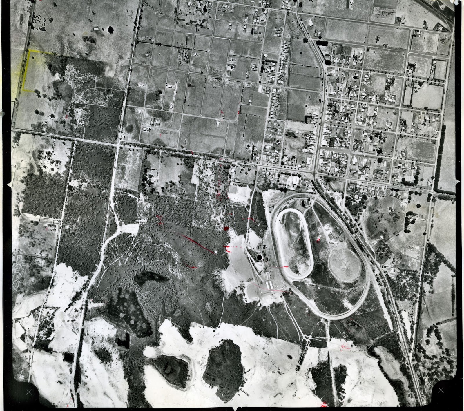
Taken in January 1972 this is the Lyndhurst/Hampton Park sand quarry. It is now the 'Hallam Road landfill'. The South Gippsland Highway runs along the left of the photograph. At the bottom right corner is part of the Cranbourne Golf Club.


This is the sand mine either side of Thompson's Road in Cranbourne. Photograph was taken January 1970. The road on the left of the photo is Narre Warren - Cranbourne Road. They still mine sand on the south side of Thompson Road. Apart from Cranbourne there are still sand mines in other parts of the region, especially around Lang Lang and Yannathan.


This aerial is from February 1964. These are the sand pits below the racecourse at Cranbourne, some of which now form the Botanic Gardens. Just to the south of the racecourse, where Earlston Circuit is now, was the Earlston Sand Mine, who had their own railway siding, from around the mid 1930s.  I believe there was also a line that went from the sand pits to Camms Road level crossing to service the  Cranbourne Sand Company, from the mid 1920s.


The South Bourke and Mornington Journal of September 6, 1917 had an article about 'A new Industry for Cranbourne'.  If you can;'t read the article, above, click on this link http://nla.gov.au/nla.news-article66192688 and it will take you to the article on Trove. Sand mining has thus been an industry in Cranbourne for nearly 100 years. 

Thursday, 3 October 2013

Hampton Park Jan 28 1970

These aerials of Hampton Park were taken on January 28, 1970, back in the days when it was just a county town. It was before the Eumemmerring By-pass was built, which was started in 1969 and completed in 1972. To see more photographs of this area, click here.


This shows the South Gippsland Highway, going from bottom right to top left of the photograph. The first road from the bottom of the picture, on the left of the Highway is Abbotts Road - it bisects the railway line. Around the middle, on the right of the Highway, is Somerville Road and above that is Pound Road.


This shows Somerville Road. The five roads on the south side are View Street, The Fairway, Parkland Avenue, Ora Street and Wren Street. On the north of Somerville Road is Bride Street, running beside the oval. On the right of the photograph is Hallam Road and it intersects with Pound Road, where the trees surrounding the four small paddocks look a bit like a swastika.  You can see the Hallam Main Drain at the top of the picture.


This photographs also shows the intersection of Hallam Road and Pound Road. It also shows the intersection where Pound Road diverts at at 45 degree angle at the Shrives Road ineresection.

Friday, 26 July 2013

Bunyip aerial photographs 1985

Last week I posted some aerial photographs of Garfield, taken by the Shire of Pakenham in November 1985. Click here to see these photographs. This week we will look at aerial photographs of Bunyip, taken at the same time also by the Shire of Pakenham.


 Bunyip, looking south, towards Recreation Reserve. The intersection is of High Street, Princess Street on the right, A'Beckett Street on the left. High Street then continues as Nash Road.


Bunyip, looking north. The intersection is of Bunyip-Modella Road with the Nar Nar Goon-Longwarry Road and the railway line. Bunyip-Modella Road becomes Hope Street, north of the railway line. 


Almost the same shot as above - Bunyip, looking north. The intersection is of Bunyip-Modella Road with the Nar Nar Goon-Longwarry Road and the railway line. Bunyip-Modella Road becomes Hope Street, north of the railway line. 


Bunyip, looking east. This is the intersection of Hope Street and Princess Street (running off the left) across to High Street. 


 Bunyip is on the Gippsland Railway line to Sale. The line runs from top to bottom, on the left of the picture (or west to east). Further left is the Nar Nar Goon-Longwarry Road. On the right of the line are the shops, hotels and Public Hall in Main Street. 


Bunyip Recreation Reserve. The road to the west of the Reserve is the Bunyip-Modella Road. You can see the Railway line, running from the top (west) to the right.