


It is 150 years since the Shire of Cranbourne was proclaimed on February 24, 1868. The Shire took over from the Cranbourne Road Board which was created in 1860. A celebration was held at Greg Clydesdale Square, High Street Cranbourne on Saturday, February 24 2018.

Proclamation of the establishment of the Shire of Cranbourne
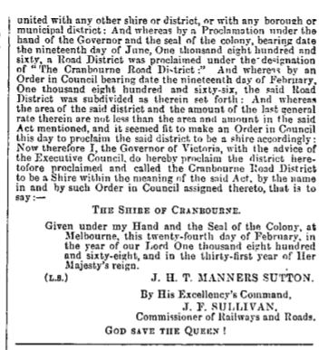
from the State Government Gazette of March 6, 1868.
You can read the proclamation better, here
Here's my time line of local government in the Cranbourne Shire area -
1860 - Cranbourne Road Board proclaimed June 19. The first members of the Cranbourne Road Board were Dr James Smith Adams, Chairman, who owned Balla Balla Estate; James Bruce, owner of Sherwood Park; Richard Burgh Chomley, owner of Tongola at Lyndhurst; James Lecky, Cranbourne land-owner who also owned the Cardinia Creek property; Edward Malloy, owner of Mayune property; Alexander Patterson, owner of St Germains Estate; Christopher Bond Peed, owner of Springmount; Patrick Thompson, owner of Oaklands and John Wedge, owner of Johnswood at Lyndhurst. Population of the Road Board area was 857.
1861 - The town of Cranbourne proclaimed on February 25.
1868 - Shire of Cranbourne proclaimed February 24. The Road Board members then became the first Councillors. They were James Lecky - Shire President; Edward Malloy, Alexander Patterson, William Norquay, Frederick Poole of Triuna, Lyndhurst; Edward John Tucker, owner of the Cranbourne Hotel; Thomas Keys, George Poole and Herbert Foley who owned Sherwood Park.
1873 - The 'agricultural area of Lang Lang' was annexed to the Shire of Cranbourne on July 4.
1875 - Cranbourne Shire Offices opened March 6. Before the Shire Offices opened meetings were held at the Cranbourne Hotel.

The Cranbourne Hotel, the venue for early Council meetings. This was built in the 1860s and demolished in the 1970s and was located around where Greg Clydesdale Square is in High Street.
1893 - Yannathan and Lang Lang East annexed from the Shire of Buln Buln to the Shire of Cranbourne on January 23.

Cranbourne Shire Offices, 1942
1978 - New Cranbourne Shire Offices officially opened in Sladen Street, April 22.
1988 - Cr Judy Elso, became the first female Shire President of the Shire of Cranbourne.
1994 - City of Cranbourne created on April 22.
1994 - The City of Casey and the Cardinia Shire officially came into being on the December 15 at 4.00pm.
The City of Casey was created from the western section of the short-lived City of Cranbourne (Cranbourne, Tooradin, Pearcedale, Devon Meadows, Hampton Park etc) and the entire City of Berwick.
The Cardinia Shire was created from the Shire of Pakenham, the eastern end of the City of Cranbourne (Koo-Wee-Rup, Lang Lang, Yannathan, Bayles, Catani etc) plus Emerald, Clematis and Avonsleigh which were annexed from the Shire of Sherbrooke. Langwarrin and Carrum Downs went to the City of Frankston from the City of Cranbourne.
The City of Cranbourne, Shire of Pakenham and City of Berwick ceased to exist on December 15 at 4.00pm.

Shire Offices 1969 - taken from the verandah of Lawson & Laura Poole's house opposite.
The Shire Offices are one of the few remaining historical buildings left in Cranbourne, we are lucky it is still there. There was a push to have it demolished in the early 1970s and it was saved by a public campaign let by the Cranbourne Shire Historical Society and Mr Herb Thomas, the owner of the Pakenham Gazette and the President of the Berwick Pakenham Historical who led a media campaign informing people of the history and worth of the building.


