Monday, 13 January 2014

Small family farms

This is our 200th blog post - the first one was on November 5, 2007 - six years ago! How time flies and I still love this blog, it is the best thing I have ever done in my working life and thank you to everyone out there who reads it!  As it is our 200th post I'm going to tell you about small family farms, which were the main stay of the rural economy of this area from around the 1880s to the 1970s and also part of my heritage. The first settlers in the area were the squatters and large (often absentee)  landowners such as the Ruffy Brothers at Cranbourne, The Reverend Hussey Burgh Macartney at Eumemmerring and Sir William Clarke of Berwick. But from the 1850s the big squatting runs were broken up, Government land sales took place and other farmers moved in. Later on these farms were subdivided again (basically 1880s onwards)  and this gave small farmers the opportunity to purchase land - this would be the pattern of settlement for the areas around Cranbourne, Berwick, Hallam and Pakenham.

These are the cows on the Rouse farm at Cora Lynn; typical of the many small dairy farms that once proliferated in the Casey Cardinia region. Photograph taken in the 1930s. 
Image: Rouse family collection.

Government land schemes to break up the large farms such as the Closer Settlement Board and Soldier Settlement subdivisons were also undertaken. Local examples of these were the  Soldier Settlement at Narre Warren North and on the Clarke land at Berwick.  The other big Government land scheme in this region was the draining of the Koo-Wee-Rup Swamp, which began in 1889, with the main works finished in 1893 although various drainage works continued until the 1960s. This land was sub-divided into farms as small as 20 acres (8 hectares). And this is where my family steps into the picture - in 1903 my great grandfather James Rouse, selected 55 acres (22 hectares) on  Murray Road at Cora Lynn. He worked this land with his son, my grandfather, Joseph Rouse. Joe was nine in 1903 when they arrived and I'm not sure if he ever went to school after they arrived, if he did it would only have been for  a few years until he left and worked on the farm. Later on, in 1922,  Joe married my grandmother, Eva Weatherhead. Eva's father Horatio Weatherhead and her brothers had arrived in Tynong North in 1909 and operated saw mills - so they are representative of the many timber workers who operated mills in the hills from the 1880 onwards, but that's another story.  Joe and Eve raised their six children on the farm. Small family farms all relied on the generally unpaid labour of all the family members - my dad and my aunties and uncle all worked on the family farm - feeding the hens, weeding the vegetable garden, feeding the calves, milking the cows, collecting the eggs, ploughing the paddocks, planting crops, fixing machinery - there was a never ending lists of tasks  - often this work was done before they went to school and after they came home.


All small family farms would have had chooks - this is my grandmother, Eva Rouse, and her eldest daughter, Nancy, photograph taken about 1930. It's one of my favourite family photographs.
Image: Rouse family collection. 

The growth of the family farm was encouraged by the establishment of railways in the area as they provided a means to send off produce to market and also provided the families with a means of transport when it was too far to go by bike or horse. In its turn, the growth of the small family farms lead to the establishment of butter and milk factories such as those at Bayles, Lang Lang and Cora Lynn; it encouarged the establishment of schools and the  growth of the towns which serviced the local farming communities. In turn, this meant that there more off-farm employment opportunities for members of family farmers and brought new people into the area.

Most small family farms also had pigs - this is my great aunt, Lucy Rouse, and my aunty Dorothy, taken around 1930.
Image: Rouse family collection. 

There are very few small family farms remaining - the small soldier settler allotments at Narre Warren North, which were about 16 to 25  acres (6 to 10 hectares) are now covered in houses, the Andrews farm at Hallam is long gone replaced by houses and factories. In the 1970s when I was at High School, you would go past operating dairies on nearly every farm; in the same area (Cora Lynn) now,  I could count the dairy farms on one hand. Farms have grown bigger everywhere and  the time has past when a small family farm is viable. Changes in society have also contributed to this - children have more opportunities in employment and education and perhaps aren't as willing to work for nothing on the family farm. However, in this 200th blog post, I am paying tribute to the small family farm that sustained the economy of the Casey Cardinia region from the 1880s to the 1970s.


Finally, even though this may have seemed like fun to my Dad, Frank (aged about 3) and his brother Jim (about 5) by the time they were in their early teens they were ploughing the paddock with horses on their own. That'a my grandfather, Joe Rouse, behind the horse. Photograph taken about 1936.
Image: Rouse family collection. 

Wednesday, 8 January 2014

Emerald Lake and Swimming Pool

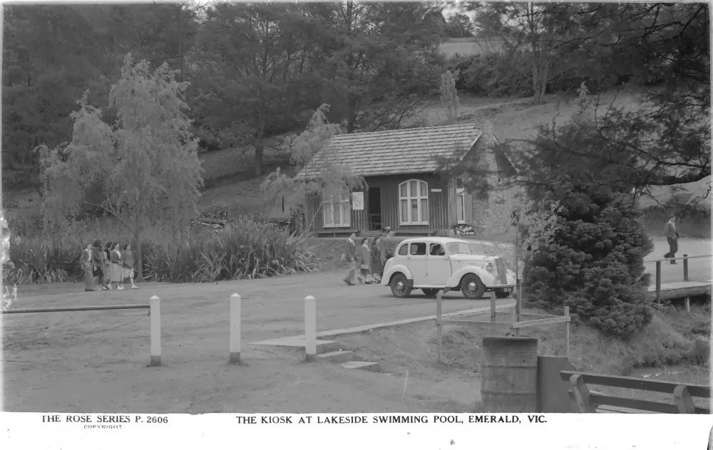
To celebrate summer I'd thought we would have a look at some great photographs of the Emerald Lake and pool, a popular swimming location for locals since the 1930s. Click here for an engaging history of the lake by Graeme Legge. These photographs are all from the State Library of Victoria collection and are all part of the Rose Series of Postcards. There are no specific dates on the photographs but I presume they are from the 1930s to 1950s.  www.slv.vic.gov.au


The Kiosk across the Lake, Emerald
State Library of Victoria Image H32492/2550


Springboard and Raft, Swimming Pool Emerald
State Library of Victoria Image H32492/148


The Drive, Swimming Pool, Emerald
State Library of Victoria Image H32492/1531


 Swimming Pool, Country Club, Emerald
State Library of Victoria Image H32492/639


A Magnificent view of the Lake, Emerald
State Library of Victoria Image H32492/2970


Spring board and water slide, Swimming Pool, Emerald
State Library of Image H32492/733


The kiosk at lakeside swimming pool, Emerald
State Library of Victoria Image H32492/3772


Kiosk and parking area, the Lake, Emerald
State Library of Victoria Image H32492/881

Monday, 16 December 2013

William A. Smith lace factory in Doveton

Lace Street in Eumemmerring is the only  reminder of the William A. Smith lace factory which operated there from 1949 to the 1980s.  When the factory was built it was in Power Road, however Power Road was later diverted around the Eumemmerring Creek and the small section of it, south of the Creek, was renamed Lace Street (see aerial photograph below). The factory was in an area which has gone through many changes of name - initially Eumemmerring, then Dandenong, from 1954 called Doveton and from 1981 called Eumemmerring (again)

This article was  in, of all papers, the Kalgoorlie Times of March 30 1948 and is about the establishment of the lace factory. It also appeared word for word in the Burnie Advocate.  

Maria Harding, in her book, Doveton: a brief history says that the factory was built in 1949 and started operations that year. Two managers houses were also built at this time.  Mrs Harding writes that this factory made handkerchiefs, napery and veils, no doubt using the products imported from the English factory. In 1953, another factory was built alongside the original one and this factory manufactured lace. A third managers residence was also built and eighty four people were employed. The factory operated until the 1980s when it closed as it could no longer compete with cheaper imports. The factory, which was on the west side of Lace Street was sold and has been demolished as have the three houses.

The employees of the lace factory in 1951.

There was an article in the Women's Weekly of April 22, 1959 entitled Dandenong: a symbol of industrial strength. This article looked at various factories in the Dandenong,  including the lace factory. They interviewed William Smith and he claims that his factory was the first in Dandenong. It goes on to say that at his 300 year old walnut desk, brought from England, Mr Smith sighed ' for the old days at Dandenong (1947) when not a light could be seen for miles at night'.  "Look at the bustle now', he said. A heavy stream of traffic packed the four-lane highway in from of the factory.


This picture accompanied the Women's Weekly article about Dandenong and shows some of the lace factory employees.
Women's Weekly of April 22, 1959    http://nla.gov.au/nla.news-article48077502


This is a 1963 aerial of Doveton / Eumemmerring. Click on photo to enlarge it. That's the tree-lined  Eumemmerring Creek, snaking through from top right to bottom left and just to the right of the Creek, at the bottom, you can see Lace Street and the two factories on the western side, along with the three Manager's houses. Further north, the two ovals are Robinson Reserve and L.S. Reid oval. The intersection middle top is that of Frawley Road/Paperbark Street with Power Road. Follow Power Road to the bottom of the photo and it intersects with the Highway.  Power Road was diverted at this end as it would have been too expensive to build a bridge to take heavy trucks*. 

 *William Smith in an interview with Maria Harding

Friday, 13 December 2013

Harkaway - Michael Drew photograph collection

Historian, Mr Max Thomson, has donated his collection of historic photographs to the State Library of Victoria. Amongst the photographs are these ones of the Harkaway Hall -  taken by Michael Drew (1873-1943). They were all on glass negatives. Mr Thomson is the author of Little Hills, a history of Narre Warren North, published in 1977 to celebrate the centenary of the Narre Warren North State School, No.1901. You can read about Michael Drew, here.

Harkaway Hall
Photographer: Michael Drew
State Library of Victoria Image H2012.171/462

The Hall looks finished on the outside, so perhaps these workmen were finishing off the interior. 

Harkaway Hall
Photographer: Michael Drew
State Library of Victoria  Image H2012.171/464

The Hall, completed and sign written, above.  The Hall was officially opened on June 9, 1909 by the Governor of Victoria, Sir Thomas Gibson Carmichael.  There is an account of the opening of the hall in the book Early Days of Berwick.   Mr James Curran, who wrote the chapter on Harkaway, reported that the Governor was escorted by a squadron of Australian Light Horse, the Narre Warren Troop, under the command of the late Lieutenant Alan Henry. The Troop also served as a Guard of Honour. 

An account of the opening of the Harkaway Hall by the Governor of Victoria, 
Sir Thomas Gibson-Carmichael, on June 9, 1909
Punch June 18, 1909


The Governor, being escorted by the Narre Warren Light Horse Regiment, to the Harkway Hall opening.
Photographer: Michael Drew
State Library of Victoria Image H2012.171/457


Opening of the Harkaway Hall, June 9, 1909.
Photographer: Michael Drew
State Library of Victoria Image H2012.171/460

The photograph, above, was taken at the opening of the hall on June 9, 1909. Mr Curran also wrote that the people associated with the establishment of the Hall were Mr G.O.Lyon, Mr W. Warby, Mr Drew, Cr W. G. A'Beckett, Cr Kerr, Cr Barr and Mesdames R. Kelly, W.H. Jarrett, E. Wanke, Miss Mackie and Miss Troupe. Perhaps some of these people are in this photograph.

Friday, 6 December 2013

Roads, Rates and Rubbish - 1980s

Traditionally, Councils had their main focus on the three Rs - Roads, Rates and Rubbish. I have spoken before about the Shire of Pakenham slides which I have scanned - so here a representative lot showing the three Rs in the 1980s!


 The Pakenham Shire and the City of Berwick were formed on October 1st, 1973 when the Shire of Berwick split, with the Cardinia Creek being the boundary. The Pakenham Shire became the  Cardinia Shire officially on the December 15, 1994 at 4.00pm. The Cardinia Shire consists on the old Pakenham Shire, the rural eastern parts of the Cranbourne Shire and Emerald and surrounds, which came from the Sherbrooke Shire.


I believe this was taken in 1993. The population of Pakenham was 25,648 at the 2011 Census.


Amongst the slides were these two, above and below, obviously done for a presentation, explaining the Rates notice and how the Shire spends its money - in 1981 when the slides were created  the Council budget was just over $5 million and 38% was spent on roads, streets and bridges. The Council budget is now about $93 million.


Rubbish - being collected in the old fashioned manner, where 'garbos' physically picked the bins. For Health and Safety reasons this has now been stopped.  Truck owned P.H & E.P Young, Ballarto Road, Cardinia.


Roads - Shire of Pakenham digger. 


Finally - just to prove that rate payers received other services for their rates - here is the Pakenham Library, taken in June 1981.  The Council obviously wasted no rate payer money on aesthetically  pleasing features when they built this building, utilitarian is perhaps the kindest description we could use.  The Library was opened in 1979, in John Street when it was a dead end, before Safeways and the Target shops were built.  There is an aerial photograph of the building here.  This Library was replaced by the second John Street Library in 1991.

Friday, 22 November 2013

Touring in the 1930s.

I have just been given this fabulous set of Shell maps. Judging by the wonderful Art Deco style cover I presume that they are from the 1930s. 


The maps also include parts of the Motor Car Act. Click on the image to enlarge it. My favourite part of this Act covers the Wind Screen Wiper. It says that Every vehicle fitted with a wind screen must have attached thereto an efficient wiper. The Act also warns us not to use a Public Highway for racing or  a trial speed and also not to sound the horn when passing Churches. And another interesting part of the Act says The law now requires drivers to signal when about to stop, turn right or when the driver requires other vehicles to pass him on his right.


However, because this is a blog about the history of the Casey Cardinia, then you may be interested in this map. If we travel along the Princes Highway from Dandenong, we get to Narre Warren. Narre Warren North is described as 'Old Narre Warren', which is what it was, I just haven't seen it described like that on a map.  Modern day Narre Warren was established when the railway station opened in 1882. If we head up to the hills, going east from Belgrave, the town of  Aura is of interest. Menzies Creek was known as Aura from 1917-1923. 

Further east we have Gembrook North and Gembrook West, names no longer in use. Also of interest, right down the bottom we have Sherwood Junction, also a name no longer used, on the corner of the South Gippsland Highway and Tooradin-Baxter Road and further east they still use the name Yallock, even though with the opening of the Bayles station in 1922, the town and the name began to fall into decline.

Wednesday, 13 November 2013

Endeavour Hills Library - 1980s

The Endeavour Hills Library was officially opened on May 31, 1987 by the Mayor of the City of Berwick, Cr Eddie Barron. Here are some photographs of the Library and the Library site from around this time.


This is the site of the Library, next to the Community Centre. The Community Centre opened October 17, 1982. The shopping centre had opened in 1979.


This is the Library site, before construction started.


The day of the opening. All participants received a commemorative bookmark, below.


Above and below, are two early photographs of the Library from 1987/1988.
 

The Library was renovated and extended in 2007.