The Country Roads Board was established in 1913 to maintain major roads in Victoria. Previous to this all roads were the responsibility of the local councils. The Public Records Office has digitised much of the CRB's photographic collection, you can access them
here. In two other posts I shown the Princes Highway photographs (see
here) and the South Gippsland Highway photos from this region (see
here). This post show four other photos of the area.
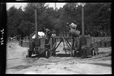
400 gallon heaters set up for spraying on the Cockatoo-Gembrook Road, 1931.
Photographer: Country Roads Board VPRS 17684 Image 30_00259
Road running North from Cockatoo station, 1913.
Photographer: Country Roads Board VPRS 17684 Image 13_00036
Brunt's gravel pits near Cranbourne, 1913.
Photographer: Country Roads Board VPRS 17684 Image 13_00183
Quarry at Tynong opened up by contractor Manrell, Pakenham, 1929.
Photographer: Country Roads Board VPRS 17684 Image 28_00201
CRB's photographic collection can be accessed
here. The CRB Princes Highway photographs from this region can be seen
here and the South Gippsland Highway photos from this region,
here.


No comments:
Post a Comment